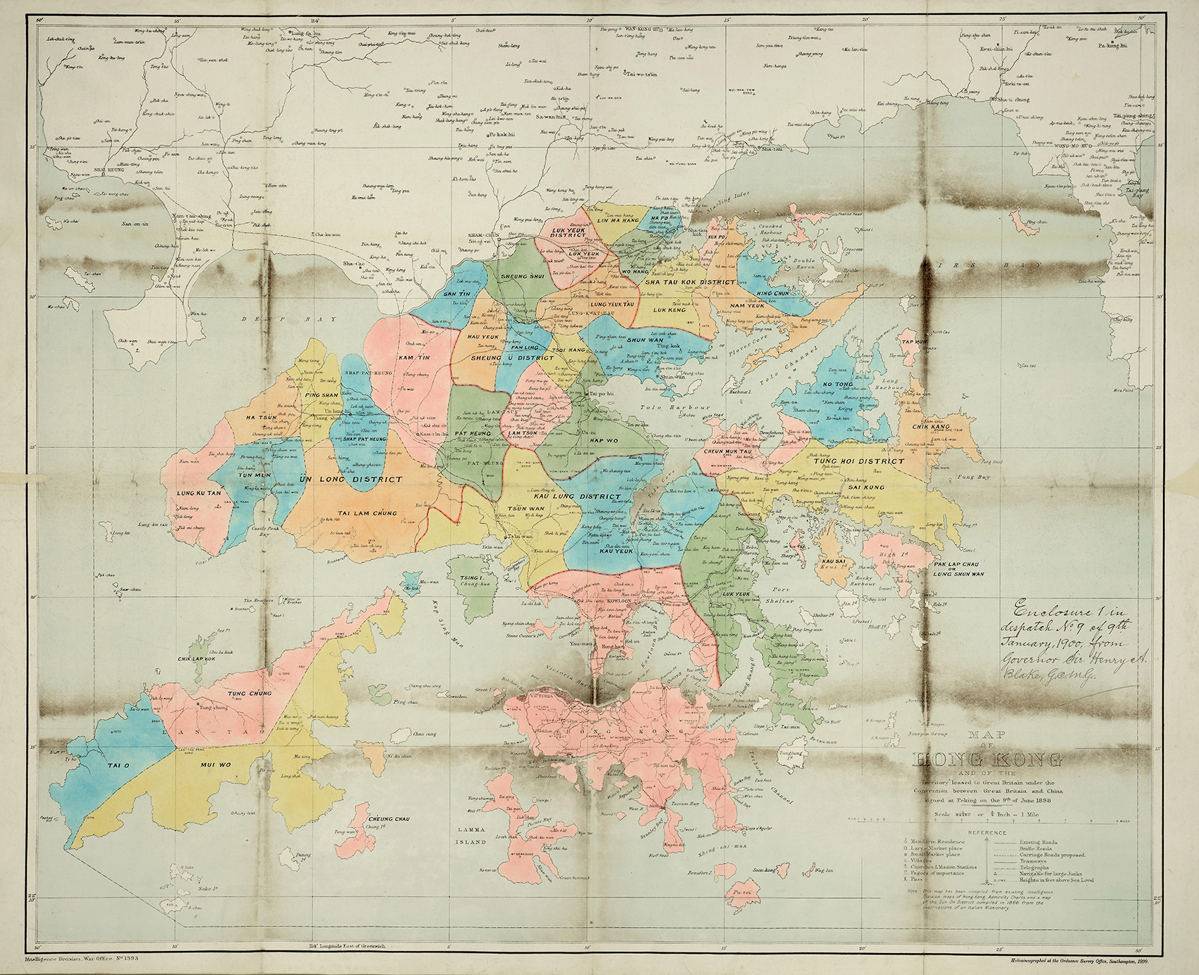
Map of Hong Kong and of the Territory leased to Great Britain, 1899 (MPG 1/796)
Transcript
Enclosure 1 in in despatch No. 9 of 9th January, 1900, from Governor Sir Henry A. Blake.
MAP
OF
HONG KONG
AND OF THE
Territory leased to Great Britain under the Convention between Great Britain and China signed at Peking on the 9th of June 1898
Scale 1/84480 or ¾ Inch = 1 Mile
REFERENCE
[Circle with flag] = Mandarin Residence
[White square] = Large Market place
[Dark square] = Small Market place
[White circle] = Villages
[White circle with crucifix] = Churches & Mission Stations
[Pagoda symbol] = Pagoda of importance
[Cross] = Pass
[Double line] = Existing Roads
[Dotted line] = Bridle Roads
[Dotted double line] = Carriage Roads proposed
[Railway line] = Tramways
[Line with dots] = Telegraphs
[Anchor symbol] = Navigable for large Junks
[Triangle followed by number] = Heights in feet above Sea Level
Note
This map has been compiled from existing intelligence Division maps of Hong Kong, Admiralty Charts and a map of the Sun On District compiled in 1866 from the observations of an Italian Missionary.
Map description
Map of Hong Kong showing Hong Kong Island, Kowloon, the New Territories, Lantau Island, Lamma Island and other surrounding islands depicted in different colours and with borders indicating different districts.
Look at sources 1a – c. These three maps show what Hong Kong looked like at three different points in history: 1841, 1868, and 1899.
- ‘Hong Kong Island’ – which is just one small part of today’s Hong Kong – is present in all three of these maps. Can you find it?
- In each map, identify which is the British territory and which is the Chinese territory.
- What do you think has happened in between each of these maps to change the borders?
- Look at a map of Hong Kong today. How similar is it to Source 1c?
- Today, Hong Kong Island is the political and economic centre of Hong Kong. Looking at these maps, why do you think that is?
