Hong Kong Sun-on District, 1868. (CO 700/HONGKONGANDCHINA3A (1))
Transcript
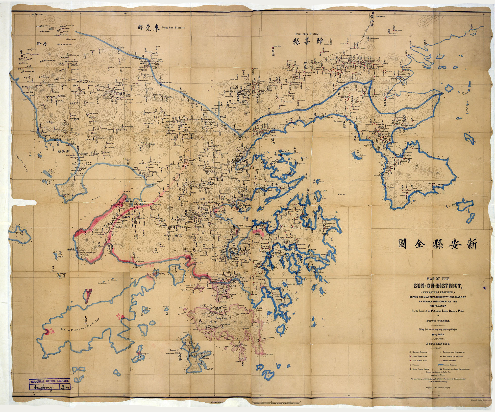
MAP OF THE
SUN-ON-DISTRICT,
(KWANGTUNG PROVINCE,)
DRAWN FROM ACTUAL OBSERVATIONS MADE BY
AN ITALIAN MISSIONARY OF THE
PROPAGANDA
In the course of his Professional Labors During a Period
OF
FOUR YEARS.
Being the first and only map hitherto published
May 1868.
REFERENCES.
[Circle with dot] = MANDARIN RESIDENCE
[Pink square with extended corners] = LARGE MARKET PLACE
[Pink square] = SMALL MARKET PLACE
[Pink circle] = VILLAGES
[Pink circle with crucifix] = ROMAN CATHOLIC CHAPEL
[Pagoda symbol] = PAGODA OF SOME CONSIDERATION
[Corridor symbol] = PASS THROUGH THE MOUNTAINS
[Light pink line] = BRITISH TERRITORY
[Blue line] = CHINESE TERRITORY
[Ship symbol] = NAVIGABLE FOR LARGE CHINESE JUNKS.
Height of the Mountains in English Feet.
Soundings in Fathoms.
The uncertain pronunciation of the Chinese Characters is fixed according to Williams’s Dictionary.
Engraved by F. A. Brockhaus, Leipzig.
Map description
Map of Hong Kong Island and the territory surrounding it. Hong Kong Island and the area just above it across the water, the bottom half of Kowloon, are outlined in light pink, as is Stone Cutter Island next to Kowloon. The rest of the land on the map, including the rest of Kowloon and today’s New Territories regions, as well as Lantau and Lamma Islands, are outlined in blue.
Look at sources 1a – c. These three maps show what Hong Kong looked like at three different points in history: 1841, 1868, and 1899.
- ‘Hong Kong Island’ – which is just one small part of today’s Hong Kong – is present in all three of these maps. Can you find it?
- In each map, identify which is the British territory and which is the Chinese territory.
- What do you think has happened in between each of these maps to change the borders?
- Look at a map of Hong Kong today. How similar is it to Source 1c?
- Today, Hong Kong Island is the political and economic centre of Hong Kong. Looking at these maps, why do you think that is?