
Important information
This story references documents that use outdated language to describe Indigenous people of North America.
A new era of British colonialism
By the mid-18th century, Britain was competing with rival empires like France and Spain for control over North American territory and resources. These empires competed for control within a highly complex political system: the continent was already home to millions of Indigenous people, across hundreds of nations.
To build a successful American empire, Britain would have to balance diplomacy with Indigenous nations as well as the interests and demands of its subjects on both sides of the Atlantic. Records at The National Archives, including transcripts of speeches by the Indigenous people involved, offer an unparalleled insight into this delicate process.
During the Seven Years War (1756–1763), Britain – supported by powerful Indigenous allies, like the Haudenosaunee Confederacy – successfully removed its French and Spanish rivals from most of the region. The Haudenosaunee are a confederacy of six Indigenous nations (the Onondaga, Mohawk, Seneca, Cayuga, Oneida, and Tuscarora), who exerted considerable influence in the Great Lakes and Ohio River Valley area.
Following the war, Britain’s territorial claims now covered the entire Atlantic coastline of North America. British America looked forward to a new age of prosperity, but it remained politically unstable.
Indigenous alliances
Because no European empire was yet powerful enough to exert sole control over North America, alliances with Indigenous nations were vital. Successful alliances provided security on both sides. The British Crown offered Indigenous nations assurances that its subjects would not advance any further on their lands. Previous advances had eroded Indigenous territory and resulted in a cycle of violence between settlers and Indigenous people. In return, Indigenous nations were expected to act as trading partners and, when called upon, military allies in conflicts with rival European nations.
These alliances also allowed Indigenous people to exert political agency. However, they became increasingly unequal and contributed to the gradual erosion of Indigenous territory by colonists. For example, the British used the Treaty of Paris, which ended the Seven Years War, to claim control over territory belonging to the Haudenosaunee.
Britain’s alliance with the Haudenosaunee proved vital for defeating the French. After the Seven Years War, access to Haudenosaunee fur traders was a promising source of colonial income. In turn, Britain’s reliance on nations like the Haudenosaunee provided those Indigenous peoples with leverage, and the ability to make demands in return.
British politicians and administrators imagined such alliances as a form of paternalistic control, with Indigenous nations operating semi-autonomously as Crown protectorates. Like many other Indigenous people, the Haudenosaunee interpreted their relationship with Britain rather differently. They formulated it as a Covenant Chain, a diplomatic compact based on mutual obligations. As Britain sought to capitalise on its imperial gains following the Seven Years War, the exact nature of these obligations would become a point of diplomatic contention.

A copy of an Indigenous map of nations between South Carolina and the Mississippi, around 1721–1725. It details areas labelled as ‘Creeks’, 'Chickasaw', 'Choctaw' and ‘English’, joined by lines indicating connecting paths and trade routes. Catalogue reference: CO 700/NorthAmericanColoniesGeneral6/2
Managing relations
In 1763, King George III issued a proclamation that limited the spread of British colonial settlement in North America. Although Britain claimed sole European access to lands stretching from the Atlantic Ocean to the Mississippi River, colonists were forbidden from establishing permanent settlements any further west than the Appalachian Mountains. In the British paternalistic perspective, these lands were preserved by the Crown as Indigenous hunting grounds. Preserving these lands enabled Britain to maintain its vital alliances with nations like the Haudenosaunee. However, it also enraged British colonists, becoming one of the major points of contention leading to the American Revolution.

[Page 37]
of Our colonies, that the several nations or tribes of Indians, with whom We are connected, and who live under our protection, should not be molested or disturbed in the possession of such parts of our dominion and territories as their hunting grounds, we do therefore, with the advice of our privy Council, declare it to be our royal will and pleasure, that no governor or commander in chief in any of our colonies of Quebec, East Florida, or West Florida do presume upon any pretence whatever to grant warrants of Survey, or pass any patents for lands beyond the bounds of their respective governments as described in their
[in the margin]
not having been ceded to or purchased by us, are reserved to them or any of them
[Crossed out] for the present & until our further pleasure is known
Section of King George III's royal proclamation limiting the spread of British colonial settlement in North America, 1763, to prevent conflict with Indigenous nations. Catalogue reference: CO 5/65/37
Whilst wealthy colonists lobbied the British government to enable further westward expansion, some British-Americans took matters into their own hands. They crossed the line anyway. This led to several violent confrontations with Indigenous people, which threatened Britain’s vital Indigenous alliances.
The British government sought a diplomatic solution that would appease both its allies and its unruly colonists – but was also, quietly, keen to expand British lands further west.
Work began on a new boundary line, which would push British settlements westward. The resulting 1768 Fort Stanwix Treaty was the conclusion of complex negotiations with various Indigenous nations. Each brought different needs, complaints, and ideas about potential colonial coexistence to the table.

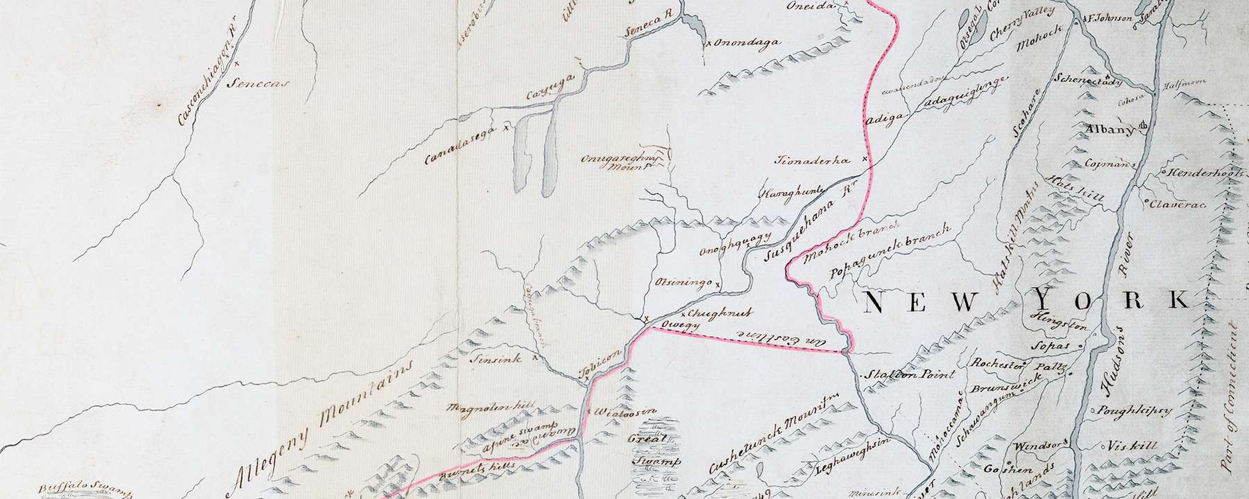
A map of the Fort Stanwix boundary line. Copied from an original map drawn at Fort Stanwix, by Guy Johnson, as part of treaty negotiations with the Haudenosaunee Confederacy, October 1768. It shows a boundary line extending from Fort Stanwix to Harts Rock on the Ohio River. Catalogue reference: WO 78/302
The superintendents
Responsibility for negotiations fell to the 'Department for Indian Affairs'. This was led by superintendents William Johnson in the Northern District (Canada to Maryland), and John Stuart in the Southern District (Virginia to Florida).
The superintendents were Indigenous nations’ first point of contact to raise any disputes with Britain and its colonists. While in post, the superintendents (and their small teams of officers and interpreters) developed close working relationships with the Indigenous nations who bordered their colonies. These relationships were strengthened through customary gift-giving and by building trustworthy reputations.
However, their correspondence shows a more bullish approach. Writing to Wills Hill (Secretary of State for the Colonies) in 1769, Johnson detailed his 'divide and conquer' approach to Indigenous diplomacy: 'It is highly necessary to prevent a too general Union amongst them... because we enjoy the most security when they are divided amongst themselves... becoming umpire in their Quarrels will prove one of the most Essential Steps towards the Government of the Indians'.
The superintendents reported directly to the Secretary of State for the Colonies in London. They typically put the government’s interests (and sometimes their own) ahead of the Thirteen Colonies or Indigenous nations.

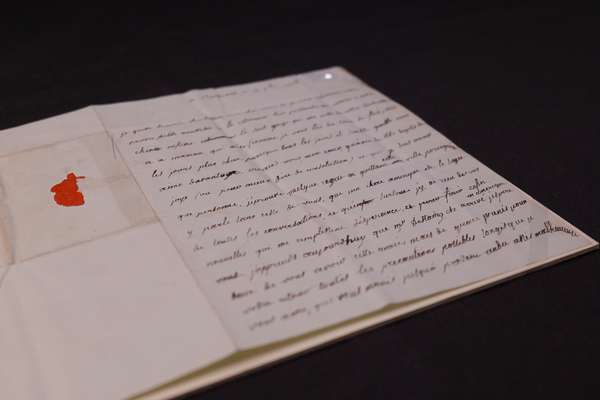
In considering this Question it may be proper to observe, that the Institution of Superintendants for the Affairs of Indians appears to have been a Measure originally adopted principally with a view to counteract the Designs of the French in 1754, who by sowing the Seeds of Jealousy amongst the Indians, and exciting them to resent Injuries, for redress of which they had in vain solicited the Colonies, had well nigh entirely weaned them from the British Interest; and at the same time by uniting the force and conducting the Enterprizes of the Savages, had rendered them an Overmatch for Your Majesty’s Colonies, standing single and disunited.
In order therefore to balance the Danger arriving from this more immediate Union and Co-operation of the French with the Indians, it became necessary to provide a more Systematical as well as more extensive plan of defence for the Colonies than had before
been requisite; a Plan, which might bear some Proportion to the extent of the Efforts then made by their Enemies, and which, having for its Object the preservation of all Your Majesty’s Colonies from the common Danger, could no otherwise be administered with Safety, or with effect, than under the immediate Control of their common Sovereign & Protector; and the Utility of such a Plan, under those Circumstances, was soon manifested by its Consequences, and by the Share it had in contributing to that Success, which ever after attended the British Arms in America.
A Board of Trade report where the role of superintendents for the 'Department for Indian Affairs' is discussed, March 1768. Catalogue reference: CO 5/69/62r
Treaty negotiations
Negotiations for the new boundary line were lengthy, consisting of various treaties and land agreements signed between 1763 and 1768. The superintendents sold the plan as a permanent solution to colonial encroachment on Indigenous lands. Johnson advised the Haudenosaunee that further land concessions were 'the best and surest Method of ending such like Disputes, and securing your Property to you beyond a possibility of Disturbance'.
Indigenous leaders recognised the potential benefits of a settlement, but previous experience led them to be sceptical. Speaking to Johnson, a representative of the Onondaga Nation cited ongoing grievances, including dishonest land sales and unfulfilled promises:
the English don't deal fairly with us… they get our names on paper very fast, and we often don't know what it is for.
CO 5/69/102
By October 1768, only the northern end of the line remained to be agreed – the portion that passed through Haudenosaunee lands. To finalise the agreement, William Johnson convened a congress of the relevant Indigenous nations, alongside governors and deputies from the British colonies, at Fort Stanwix (now around 50 miles from Syracuse, New York).
This northern section of the boundary had proven particularly troublesome, with particular disagreement over the section covering the Mohawk lands east of Oneida Lake. The Haudenosaunee wanted to preserve more of their land and put the line further east, crossing the Mohawk River at Governor Cosby’s Land (now Utica, New York) before striking east towards Lake George.
However, various British colonists – including Johnson himself – had already purchased lands in the area from members of the Mohawk Nation. Johnson pressured the Haudenosaunee negotiators to move the line about 20 miles further west to the confluence of Wood Creek and Canada Creek (near Fort Stanwix itself). This would mean these lands would be firmly incorporated within the boundary.
Johnson succeeded, but by doing so he jeopardised the integrity of the whole boundary line. The Haudenosaunee were able to demand concessions from the British. They had recently concluded a lengthy conflict with the Cherokee Nation, and claimed control over large areas of Cherokee land by right of conquest. They proposed that the section of the line passing through those Cherokee lands be redrawn, expanding the British claim further south. The Haudenosaunee hoped this would divert the inevitable influx of British settlers away from their lands, whilst forcing British recognition of their territorial claims.

At a Treaty with the Six Nations, Shawanese,
Delawares, Senecas of Ohio, and Dependents &c opened
at Fort Stanwix on Monday the 24th day of October 1768
Present
The Honorable Sir William Johnson Baronet
Superintendent.
His Excellency William Franklin Esquire Governor of
New Jersey.
Thomas Walker Esquire Commissioner from the Colony
of Virginia.
The Honorable Frederick Smith Chief Justice of
New Jersey.
Richard Peters, and James Tilghman, Commissioners
from the Province of Pennsylvania.
George Croghan,
Daniel Claus, Esquires, Deputy Agents of Indian Affairs
Guy Johnson Esquire Deputy Agent as Secretary
With Sundry Gentlemen from different Colonies
John Butler Esquire,
Mr Andrew Montare,
Philip Philips, Interpreters.
Indian Chiefs present:
Mohawks:
Abraham
Kanadagaya
Kendrick
Arighiadecka
Kayenqueregoa
Tobaruhoga
Onohario
with others
Onondagas:
The Bunt
Tewawuvit
Diaguanda
Tawashughti
with others
Senecas:
Ganstrax
Odongot
with others
Oneidas:
Ganaghquieson
Nicholasera
Senughsis
Gajuheta
Tagawaron
with others
Cayugas:
Tagaaia
Skanariady
Atrawawna
with others
Tuscaroras:
Saquareaiora
Kanigot
Tyagawetie
with others
Mingoes of Ohio
Shawanese:
Benevissica
Delawares:
Killbuck
Twitteheart
A transcript of the Fort Stanwix treaty negotiations, 1768, with a list of Indigenous and British delegates in attendance. Catalogue reference: CO 5/69/315r
A fragile conclusion
With these revisions, Johnson overrode Stuart’s carefully laid agreements with the Cherokee. He was firmly rebuked by Wills Hill, but there was little the government in London could do. Johnson suggested that Britain’s alliance with the Haudenosaunee was too delicate, and too vital to the security of the American colonies, to risk. He argued that the Haudenosaunee were 'more powerful, more Jealous, more Warlike and capable of doing us infinitely more mischief' than the Cherokee.
Meanwhile, Johnson’s line simply looked like a better offer for Britain. It added vast areas in what would become Kentucky, West Virginia, and Pennsylvania’s New Purchase to the British Empire. Britain, like its colonists, was hungry for land. As Johnson told Hill:
I did humbly conceive it to be the desire of Government to get as extensive a Cession as was practicable.
CO 5/70/234
Judging good relations with the Haudenosaunee to be more valuable than with the Cherokee, and tempted by the possibility of westward expansion that might appease their increasingly rebellious American colonies, the British government confirmed Johnson’s version of the Treaty of Fort Stanwix.

South Carolina
Extract from a Cession of Lands by the Cherokees to the Province of South Carolina, dated Fort Prince George October 19 1765.
We, whose Names are under written, and Seals affixed, Warriors, and head beloved Men of the Cherokees, Plenipotentiaries for the Over Hills, Valley, middle and lower Settlements, and especially authorized and deputed by the whole Body of the Cherokee Nation, Certify by these presents, that at a Congress held between Us and George Price, Ensign of His Majesty’s 60th Regiment Commanding Officer of Fort Prince George, and Alexander Cameron Esquire Commissary for Indian Affairs acting in the Behalf of His Britanick Majesty and his Subjects, We have ceded to the English: That Tract of land (which previous to this time we deemed our own) lying between a Brook known to the white People by the Name of Dewisses Corner, and to us by the Yellow Water; and another Brook distant from the former about ten Miles; and known to both white and red People by the Name of Long Canes.
1765 December 10, approved by William Bull Esquire Governor of South Carolina. 1766 January 10, approved by John Stuart Esquire Superintendant.
Extract of Cherokee 1765 land cession, as part of wider negotiations for establishing land borders between the Cherokee and British settlers. Catalogue reference: CO 5/69/94
The result was a catastrophe on both sides. The Cherokee, and neighbouring nations like the Shawnee, faced a massive influx of colonists into the lands ceded away by the Haudenosaunee, which prompted further outbreaks of violence. By 1774, the Virginia colony was embroiled in an armed conflict with the Shawnee and Mingo nations (known as Lord Dunmore’s War).
Many British colonists saw these violent episodes as a result of the government’s failure to properly settle the boundary line. As a result, the Fort Stanwix Treaty not only endangered Britain’s relations with its Indigenous allies, but also those with its increasingly rebellious subjects in North America. These simmering resentments would come to a boil with the outbreak of the American Revolutionary War in 1775.
Exhibition
Revolution 250: America's Independence Story 1763–1783

Marking the 250th anniversary of The US Declaration of Independence, this powerful free exhibition charts the emergence of the United States of America.
Records featured in this article
-
- From our collection
- CO 700/NorthAmericanColoniesGeneral6/2
- Title
- Indigenous map of nations between South Carolina and the Mississippi
- Date
- 1721–1725
-
- From our collection
- CO 5/65
- Title
- Correspondence, Secretary of State: Indian affairs
- Date
- 1760–1764
-
- From our collection
- WO 78/302
- Title
- Map of North America
- Date
- 1768
-
- From our collection
- CO 5/69
- Title
- Records on affairs of Indigenous nations
- Date
- 1767–1768