How to look for records of... Military maps of the First World War
How can I view the records covered in this guide?
How many are online?
- None
Contents
- 1. Why use this guide?
- 2. How to use this guide and get a search for maps started
- 3. Main map collections of the First World War
- 4. First World War maps within war diaries
- 5. Other record series containing First World War military maps
- 6. How to find trench maps of the Western Front by sheet number
- 7. First World War maps held elsewhere
- 8. Reproductions and published facsimiles of First World War military maps
- 9. Appendix 1: The usage of maps on the Western Front
- 10. Appendix 2: The sheet numbering system for maps of the Western Front
- 11. Appendix 3: The grid referencing system for maps of the Western Front
- 12. Further reading
1. Why use this guide?
Use this guide if you are looking for trench maps or other military maps of the First World War. The National Archives holds many thousands of military maps from the First World War period. Many of them are official maps made by or for the British government and armed services. Others are foreign maps that were acquired and used by the War Office.
You may find it useful to look at maps alongside written records about First World War events, strategy and operations.
This guide also includes brief outlines of how the systems of map sheet numbers and grid references work for maps of the Western Front.
Most of these records are not viewable online. To view records which are not online you will need to visit The National Archives at Kew or request copies.
2. How to use this guide and get a search for maps started
A search for records of any kind, including maps, at The National Archives usually begins in our online catalogue. The following sections of this guide provide links to key record series that you can search within our catalogue, helping you to target your searches more precisely. By clicking on the series links (for example, WO 300) you will arrive on the respective ‘series description’ pages from where you can search the series, using dates/years and keywords such as:
- place name
- the name of a battle or operation
- the name of a regiment or other army unit
It’s usually worth including the phrase AND (map OR plan) after the other words that you are searching with. In some cases, the best way to search for maps is by map sheet number. You may need to use an index map to identify sheet numbers. Where index maps exist, we have flagged this in the guide.
There are some record series made up solely of First World War maps (see ‘Main map collections’ section) and these tend to be easier to find. However, there are also lots of military maps within wider record series, containing, for example, all kinds of operational records, and many of the maps in these kinds of series have not been identified in the catalogue description.
Use the advanced catalogue search to restrict your search results to all the records of a specific government department, including its predecessors (for example, the War Office). Use the department reference, which is always a letter code, to do this (the code for the War Office is WO).
Catalogue search results provide short descriptions of our records and a document reference for each one – you will need the document references to see the maps themselves. Very few of the maps covered in this guide are available to view online so to see them you will have to either visit us in Kew or order copies.
3. Main map collections of the First World War
The record series WO 153 contains maps showing the progress of the war in various parts of the world. Many of these are printed maps with manuscript annotations.
Most of these maps are bound portfolios, not individual sheets. Try searching by one of the following:
- theatre of war (for instance, “East Africa”)
- name of major operation or battle (for instance, “Vimy Ridge”)
- number of army or corps (for instance, “Third Army” or “XIV Corps”)
Restrict your search by date to the relevant year or years.
We also have separate accumulations of maps for the following individual theatres of war:
- WO 300 for East Africa. Index maps are in WO 300/1-12
- WO 369 for Italy. Index maps are in WO 369/1-28
- WO 301 for Gallipoli and Dardanelles. Index maps are in WO 301/1-44
- WO 302 for Mesopotamia. Index maps are in WO 302/1-37
- WO 303 for Palestine. Index maps are in WO 303/1-12
- WO 298 for Salonika
- WO 297 for the Western Front. A useful index map is available in the reading rooms at The National Archives and in Peter Chasseaud’s Topography of Armageddon (Lewes, 1991). Other index maps are in WO 297/1-56.
Most of these maps are individual sheets. Try searching our catalogue by sheet number or place name. Restrict your search by date to the relevant year or years.
Alternatively, browse the relevant sections of the catalogue using the ‘browse by hierarchy’ option.
For guidance on searching for trench maps of the Western Front by sheet number, see the separate section below.
4. First World War maps within war diaries
Many war diaries in WO 95 include printed or hand-drawn maps and plans to illustrate the text. These maps and plans are not noted individually in the catalogue.
For guidance on searching for war diaries, please see our guide to British Army Operations in the First World War.
Some maps were taken out of the war diaries after the war for the use of the authors of the Official History of the Great War. These are now among the maps in WO 153.
War diaries often refer to specific locations on maps by grid reference (for example, R20 b 8.5). See Appendix 3 for more information on how the grid referencing system works.
If there is no map in the war diary itself, you can search our catalogue for one within record series WO 297 or WO 153.
Unless the war diary specifies the map sheet number as well as the grid reference, you may need to check the index map to identify the relevant map sheet. See Section 7. on how to find trench maps by sheet number.
5. Other record series containing First World War military maps
Other record series of files also contain some First World War maps. Search speculatively within the following series:
You can also search by place name within the following general series of maps:
Catalogues of printed War Office maps from the First World War period are in WO 401/5-10.
6. How to find trench maps of the Western Front by sheet number
Searching for a 1:10,000-scale trench map covering a specific area involves several stages.
Step 1
Use the index map in the reading rooms at The National Archives to find the relevant sheet number. The sheet number will look something like 57C SW 3. See Appendix 2 for more information about how the sheet numbering system works.
The index map is not very detailed. You may need to look for the names of nearby towns. If necessary, look at a modern printed atlas or modern online map first to work out the approximate position of the area that you want.
Step 2
You can search the catalogue for the sheet number. For instance, search for “57C SW 3” AND “WO 297”. (The search may not work correctly without this spacing and double quotation marks.) It may be helpful to sort your search results by reference or by date.
Alternatively, you can browse the relevant portions of the catalogue: WO 297/513-1661 and WO 297/6543-6649. There is also a typescript index in the reading rooms at The National Archives.
Step 3
Choose the map with the nearest available date. Look for the words ‘trenches corrected to’ in the catalogue entry.
If you want a map that shows both British and German trenches, look for a catalogue entry that includes ‘(S)’ (for Secret Edition) or ‘Lines A/G’ (for Allied and German lines).
Looking at the map
Once you have ordered the correct map, it is not normally difficult to understand. Most of the 1:10,000-scale maps include keys to the symbols and abbreviations used at the bottom of the sheet. Sometimes there is more information on the back.
For most of the war, German trenches are marked in red and Allied trenches (where shown) are marked in blue. From July 1918 onwards, the colours are reversed: German trenches are shown in blue and Allied trenches in red.
Alternative means of searching
If you cannot find a suitable map using this method, try one of the following alternatives:
- Look for a map that is slightly earlier or later in date. Some map sheets were updated less often than others
- Look for a map at the scale of 1:20,000. For instance, search for 57C SW (instead of 57C SW 3) in our catalogue or browse the section of the catalogue covering WO 297/2551-4164
- Look in the separate sequence of maps arranged by sheet title. Browse the section of the catalogue covering WO 297/1662-2460, or search by place name or operation title
- Search for maps within WO 153, WO 95 or one of the other record series mentioned in this guide
7. First World War maps held elsewhere
Other libraries and archives hold significant collections of trench maps and other published First World War maps. These include:
- Imperial War Museum
- British Library and other legal deposit libraries
- Royal Geographical Society
- National Library of Scotland which has images of some First World War military maps on its website
Use Library Hub Discover to find maps in the collections of some major UK research libraries.
8. Reproductions and published facsimiles of First World War military maps
Reproductions of trench maps in digital form include:
- Imperial War Museum Trench Map Archive (London, 2000) CD-ROM
- British Trench Map Atlas: The Western Front, 1914-18 (London, 2008) DVD-ROM
Facsimile reproductions of some trench maps have been published in paper form. A selection is available from The National Archives’ bookshop. Copies of these maps are also available in the reading rooms at The National Archives.
High-quality reproductions of some First World War maps are available from The National Archives’ Image Library.
9. Appendix 1: The usage of maps on the Western Front
About 34 million official British military maps were produced for the Western Front. They were produced at various scales for different purposes. The main scales are:
- 1:40,000 (1 inch to 0.63 miles). Administration maps
- 1:20,000 (1 inch to 0.31 miles). Heavy/Medium artillery maps, used as a precise locational aid for pinpointing particular targets
- 1:10,000 (1 inch to 0.16 miles). Trench maps, used for patrols and raids at a local level
- 1:5,000 (1 inch to 0.08 miles). Local operations maps, used for similar purposes to the trench maps
Most of the larger-scale maps showed the German trench systems in detail but not the British trench systems.
‘Secret’ editions of some maps were produced from September 1915 onwards. These showed the British trenches in detail too.
10. Appendix 2: The sheet numbering system for maps of the Western Front
Many maps at the scales of 1:40,000, 1:20,000 and 1:10,000 were made according to a common sheet numbering system.
The relevant parts of France and Belgium are divided in large numbered rectangles, each measuring about 20 miles west-to-east by 12.5 miles north-to-south. Each of these corresponds to a 1:40,000-scale map sheet.
Sheets covering France only are given a two-figure number followed by a letter. Sheets covering Belgium only or parts of both countries are given a two-figure number.
Examples of 1:40,000 sheet numbers: 36, 57B, 62C.
Each 1:20,000-scale map sheet corresponds to a quarter of a 1:40,000-scale sheet, indicated with the letters NW, NE, SW or SE.
Examples of 1:20,000 sheet numbers: 36 NE, 57B NW, 62C SW.
Each 1:10,000-scale map sheet corresponds to a quarter of a 1:20,000-scale sheet or a sixteenth of a 1:40,000-scale sheet. These sheets are distinguished with the numbers 1-4.
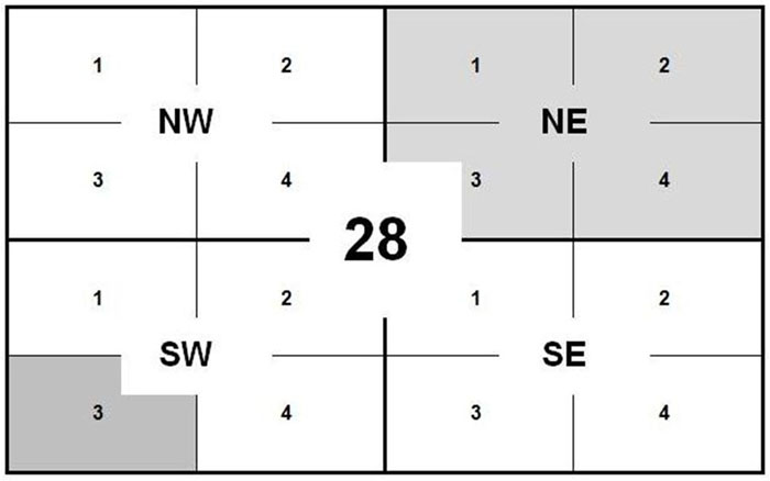
The shaded areas in the diagram above correspond to the 1:20,000 sheet 28 NE and the 1:10,000 sheet 28 SW 3.
Sometimes ‘combined sheets’ were produced, covering parts of two of the ordinary sheets. Examples include: 36 NW 2 & NE 1, 57D SE 1 & 2.
Many 1:10,000-scale maps have titles (which are place names) as well as sheet numbers. For example, sheet 28 SW 3 is also called Bailleul. These sheet titles are not currently included in our catalogue entries.
Maps without sheet numbers
Maps at the scale of 1:5,000 and some maps made at the other scales did not correspond to the sheet numbering system. Instead, these maps have titles, which are listed in our catalogue. These sheet titles are often obscure, Some of them refer to operations or battlefield features.
Examples of map sheet titles: Second Army Front Map F, Lone Tree.
Examples of 1:10,000 sheet numbers: 36 NE 3, 57B NW 1, 62C SW 4.
11. Appendix 3: The grid referencing system for maps of the Western Front
The system of grid references is used to identify specific locations on printed British military maps. The same grid referencing system is marked on maps at different scales.
The grid references are separate from but related to the system of map sheet numbers. If an entry in a war diary includes a grid reference but not a map sheet number, you will need to identify a suitable map before you can make sense of the grid reference.
The area covered by each 1:40,000-scale map sheet is divided in large squares, each identified by a capital letter. These large squares are divided into either 30 or 36 smaller squares, each measuring 1000 yards by 1000 yards. The smaller squares are given numbers.
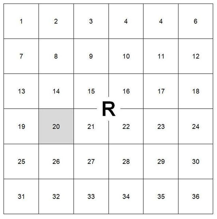
The shaded square in the diagram above is R20.
Each numbered square is further divided into four squares, each measuring 500 yards by 500 yards. These small squares are identified by the lower-case letters, a, b, c and d. These letters are not normally marked on the maps.
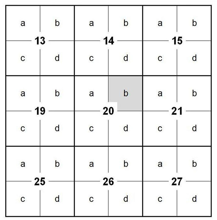
The shaded square in the diagram above is R20 b.
Within these small squares, specific points can be identified by numbers. These numbers work by dividing the square into an imaginary 10 by 10 grid. On some of the maps the grid lines are marked out in tenths to make working out grid references easier.
The divisions going horizontally west to east are called ‘eastings’. Those going vertically south to north are called ‘northings’. The eastings figure is written first, followed by the northings figure. The two may or may not be separated by a dot.
For example, to find the point specified by grid reference R 20 b 8.5:
- Find square R 20 b on the map
- Count or estimate 8/10 of the way across the square (from west to east)
- Count or estimate 5/10 of the way up the square (from south to north)
This point is accurate to within an area of 50 yards square.
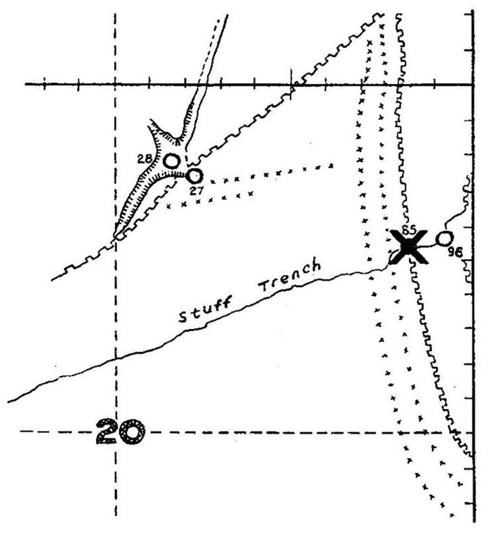
A reduced-size copy of part of a map of St Pierre Divion. (TNA reference WO 297/318)
The diagram above shows the location (marked ‘X’) of R 20 b 8.5 on a 1:5,000-scale map. (This is a reduced-size copy of part of a map of St Pierre Divion. Reference WO 297/318).
On some 1:5,000-scale maps, points of interest (such as a junction between two trenches) are labelled with partial grid references.
Sometimes grid references are made more specific for greater accuracy. If a grid reference ends with four figures instead of two, the first two are the eastings and the remaining two are the northings.
For example, to find the point specified by grid reference R 20 b 82.53:
- Find square R 20 b on the map
- Estimate 82% of the way across the square (from west to east)
- Estimate 53% of the way up the square (from south to north)
This point is accurate to within an area of 5 yards square.
12. Further reading
A A Banks and A Palmer, A Military Atlas of the First World War (London, 1975)
Geraldine Beech: Military Maps of the Western Front in Ancestors, no 8, June/July 2002
P Chausseaud, Trench Maps: A Collectors Guide. vol 1: British Regular Series. 1:10,000 Trench Maps (GSGS 3062) (Lewes, 1986)
Peter Chasseaud, Topography of Armageddon (Lewes, 1991)
Peter Chasseaud, Artillery’s Astrologers (Lewes, 1999)
Peter Chasseaud, Mapping the First World War : the Great War through maps from 1914-1918 (Collins, 2013)
P Doyle and M R Bennett, ‘Military Geography: Terrain Evaluation and the British Western Front, 1914-1918’, Geographical Journal 163, 1997, pp1-24
J E Edmonds, Military Operations in the Western Theatre of War 1914-18 (History of the Great War) (London, HMSO, 1922)
S Forty Mapping the First World War: Battlefields of the Great Conflict from Above (London, 2013)
A R Hinks, ‘German War Maps and Survey’, Geographical Journal 53, 1919, pp30-44
W B R King, ‘Geological Work on the Western Front’, Geographical Journal 54, 1919, pp201-221
Documentation about military surveying during the First World War is available on the Defence Surveyors’ Association website.