


Weather in The National Archives
The weather shapes relationships between people and their environments, and has long informed ideas of place, from the local to the global. Predicting, measuring, and understanding the weather has been critical for many activities, from agriculture, food production, and land use, to travel and exploration, military and colonial projects, and disaster response. Evidence of the importance of weather, meteorology, and climate can be found in many places at The National Archives, from some of our earliest documents to the latest research into collection care and archival climate control.
Designs registered for copyright protection under the Copyright Act of 1842 and subsequent Acts feature many barometers, thermometers, and other instruments, reflecting the development of meteorology. Maritime records include detailed ships’ logs and other documents, which often reveal how vulnerable those at sea were in the face of nature’s uncontrollable forces. Individual ‘extreme weather’ events leave their trace in the archive, too. For example, petitions and letters in the State Papers tell of the plight of thousands of sailors who drowned off the south coast of England in the Great Storm of 1703. Almost 300 years later, multiple government departments from the Home Office to the Ministry of Agriculture, Food, and Fisheries were involved in the response to the ‘peacetime emergency’ of the storm of October 1987.
Major events such as these storms represent some of the more obvious reasons why the weather features in the record-keeping of the state. Yet across the centuries, documents at The National Archives reveal some of the complex interactions between people, place, and weather in other ways. In this article we explore three different contexts for documenting these relationships, from medieval wind power to contemporary climate control in the archive.
Medieval windmills in the Humber
Anyone who has visited Spurn Point in East Yorkshire, a peninsula stretching out from the north bank of the River Humber into its estuary, will know that it is a very windy place. If you stand on the peninsula today, facing the sea, you will see an offshore wind farm on the horizon, its white blades turning. Exploiting this windy landscape is not a modern phenomenon, however.

Spurn Point, photographed in 2013.
Manorial accounts at The National Archives give us an insight into how people took advantage of the emergence of an island in the River Humber in the Middle Ages. The island in question, known today as Ravenser Odd, rose from the sea around the 1230s and had washed away by the 1360s. In its short life, it was an important site of international trade and became a royal borough that sent representatives to parliament. Here we will focus on the inhabitants’ use of wind power.
The manorial accounts for Holderness, the area to the north of the Humber, include extensive details on Ravenser Odd. These accounts are held centrally because the lordship of Holderness passed back to the crown after the death of Lady Isabella de Fortibus, without an heir, in 1293. The first manorial account that exists for the island notes that the operation of a windmill was rented out for 40 shillings.
-
- From our collection
- SC 6/1078/8
- Title
- Manorial accounts for Holderness first mentioning a windmill
- Date
- 1263–1264
At this point, the island had only existed for around 30 years, so the building of the windmill must have been one of the first actions. The potential to exploit the power of the wind was probably one of the reasons to begin settling the island in the first place, along with how easily incoming trade could be intercepted from it.
Records show this windmill continued to be rented out until the 1277–78 manorial accounts, which note incoming rent of £4, 13 shillings and 4 pence for the rent of two windmills. The expenses for the same year have details on the 35-shilling cost to build the new windmill, including carrying materials from Beverley. By this point, not long after the first mention of a windmill in the accounts, it was obviously beneficial to the islanders to expand their operation, and they did so again. The accounts in 1289–90 record three windmills on the island, bringing in £7, 13 shillings and 4 pence in rent.
In the account covering 1311–12, the scribe records a disaster. Two windmills ‘were brought down by a storm and the flooding of the waters of the sea’ (‘prostrata fuerunt per tempestatem et inundacionem aque maris’). The accounts for 1318–19 record outgoings to pay for a new arm (‘brachium’) of one windmill.

Windmill repairs in manorial accounts. Catalogue reference: SC 6/1081/10
In the accounts for 1331–32, 20 years after the original destruction, the bailiff records that the two windmills that were brought down ‘have still not been re-erected and also the greater part of the same town was destroyed and carried away by the waters of the sea and the Humber’.
The very thing that made the town so suitable for wind power, its position at the mouth of the estuary, also made it extremely vulnerable to flooding and erosion.
Finally, a bill for rebuilding one of the windmills is recorded in the accounts for 1337–1338. It must have been seen as worth the islanders’ while to rebuild, even though they were simultaneously petitioning the king for tax relief as the island was eroding so rapidly. The rebuilding did not turn out to be a great investment, as the island and its windmills did not last long after this. The final manorial account for Ravenser Odd, from 1353–54, has a blank space next to the island’s name.
The story of Ravenser Odd is a dramatic demonstration of how unexpected medieval documents can be used to investigate historical weather. The manorial accounts were designed so the bailiff could render his accounts to his lord, but we can use them today to trace the islanders’ use of wind power in good times and bad.
The story of
Ravenser Odd
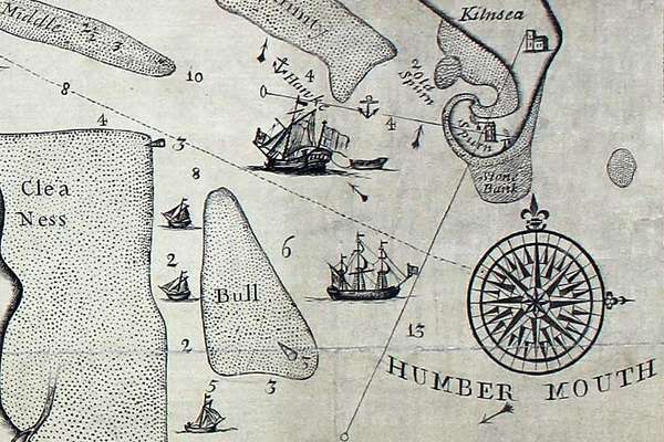
Ravenser Odd was a short-lived island in the mouth of the River Humber. It rose from the sea in the early 13th century and had sunk beneath the waves by 1360.
Government-sponsored research in ‘the tropics’
In the early 20th century, the British government administered numerous scientific research committees and centres, often as part of its colonial activities. One such institution was the Tropical Testing Establishment, based in Lagos and Port Harcourt, Nigeria. It operated from the 1940s until the 1960s, including after Nigeria gained independence in 1960.
The Tropical Testing Establishment merged two previously existing specialist units, the West African Tropical Testing Establishment, and the Signals and Radar Tropical Testing Establishment, which had been set up to carry out storage and exposure tests on service equipment for use in the tropics. It published hundreds of reports, now catalogued in record series AVIA 45, on the results of resilience tests carried out on a vast array of different objects. These range from 'the behaviour in tropical waters' of the 'Neoprene diving suit', to 'the behaviour in tropical use' of 'clockwork mechanisms', ‘wireless sets’, ‘paints’, and ‘cables’.
-
- From our collection
- AVIA 45
- Title
- Reports from the Tropical Testing Establishment, Nigeria
- Date
- 1944 to 1958
One set of reports (consisting of documents from 1955, 1956, 1956 again and a summary from 1957) focuses on ‘book bindings’. It describes a series of exposure tests which assessed the effectiveness of various chemical treatments for protecting books from fungal and insect damage in the ‘hot and humid’ conditions of Port Harcourt, and the ‘hot and dry’ conditions at Kano (also in Nigeria).
Like all reports from the Tropical Testing Establishment, these reports each follow a similar structure: an outline of the experiment, tables of results, and charts of meteorological data from the testing and observation periods.

DETERIORATION OF TREATED BOOK BINDINGS
Final Report
by
R.A. Secker
SUMMARY.
A number of books, the bindings of which had been treated with different fungicides, were exposed for two years under good and poor storage conditions at two sites in the tropics. They were examined periodically and the damage caused by fungal and insect attack assessed. Those in bad storage at Kano showed heavy fungal damage soon after they were exposed: some of these books were also attacked by termites during the earlier part of the exposure period, but most of the damage was microbiological. Books exposed to poor storage conditions at Port Harcourt in some cases suffered considerable fungal attack but were generally in much better condition than those at Kano. Under good storage conditions deterioration was very slight at both sites.
Report summary on book bindings by the Tropical Testing Establishment, 1957. Catalogue reference: AVIA 45/296
In the examples from the Tropical Testing Establishment, data collection was part of a programme of materials-testing in a climate very different from that of Britain. In the context of colonial activity in ‘the tropics’, the gathering of meteorological information served specific interests. It may imply biased assumptions about place – nothing is recorded here about indigenous understandings of local weather and climate.
While experiments on book bindings imply an official interest in keeping government records safe in ‘tropical’ conditions, these records also illustrate the prevalence of historical weather data in the archive. Tables, charts, graphs, and other representations of meteorological information can be found right across the collection. Such data was gathered in many different contexts, and recorded for a wide variety of purposes.

Weather data recorded in Kano, Nigeria, 1956. Catalogue reference: AVIA 45/296
The extensive measuring and testing undertaken by the Tropical Testing Establishment was part of the active development of new technologies to control people and landscapes, including through military force. It was undertaken in the context of Cold War proxy conflicts, and liberation struggles at the end of British imperial rule. These records are therefore also a reminder that environmental histories are entangled with histories of empire.
Weather and the future of the archive
Since 2023, The National Archives has undertaken a large-scale renewal of its environmental monitoring infrastructure. It has replaced a legacy telemetric system with a distributed network of over 400 Internet of Things (IoT) sensors, devices all capable of collecting, recording and sharing data in real time. This has grown out of the core work we do to preserve the collections we hold, but it also reflects broader issues of sustainability, energy efficiency, and climate adaptation.
While weather and climate have historically been captured in records as external events, they also influence the insides of buildings, including our own. The daily rhythms of outdoor weather interact with the built fabric of archival repositories and with the heating, ventilation and air conditioning (HVAC) technologies used to control them. Understanding these interactions is essential for anticipating how archival environments will respond to changes in building fabric, patterns of use, or broader shifts in the external climate.

Environmental monitoring of The National Archives' external conditions using IoT Weather Station software.
The new network-based system enables more detailed and continuous tracking of environmental parameters. Alongside temperature and relative humidity, long recognised as the primary factors that affect chemical degradation and mould growth in paper, the sensors also monitor carbon dioxide, volatile organic compounds, light, and motion. The influence of solar gain through windows, or the impact of staff activity in repositories, can now be monitored. These additional metrics offer new ways of identifying microclimates.
This new sensor system allows for comparative studies between internal records and external weather station data. We can explore how insulation upgrades, changes to HVAC regimes, or new building materials alter the relationship between inside and outside conditions over time. This capacity to map and interpret subtle environmental dynamics provides a framework for assessing both collection risks and building performance.

Environmental monitoring by a sensor inside The National Archives' repositories.
Research using this system aims not only to document variance across repositories but also to translate raw sensor data into preservation-focused tools. One key strand is the development of permanence maps that visualise how fast collections are likely to degrade under observed conditions. Although still at an early stage, this approach demonstrates how environmental monitoring can move towards more dynamic, evidence-based strategies for balancing preservation with sustainability.
Such research highlights the continuing importance of weather and climate in the records of the state, as an active force shaping the very conditions of their survival.


