The story of
John Blanke
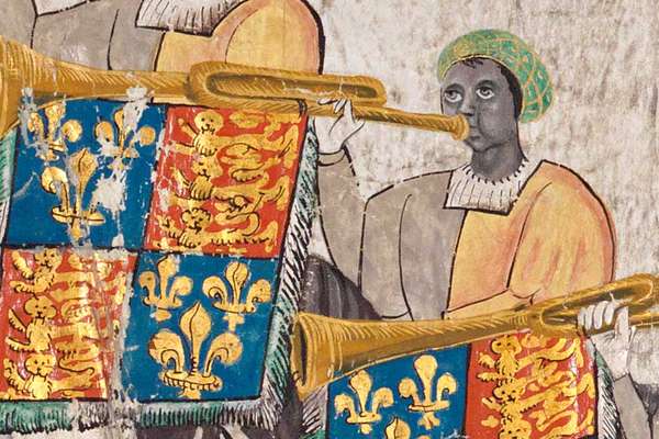
John Blanke was a trumpeter at the courts of Henry VII and Henry VIII. He is one of the earliest people of colour in England we have records about.
Do you have access to a 3D printer? If so, you can download the below STL files for free and print them!

The National Archives and All Able Ltd have embarked on a pilot project to create tactile alternatives for a selection of our records. The National Archives wants everyone to be able to engage with our records and the history they represent. This project has been focussed on creating tactile alternatives to support wider Special Education Needs and Disabilities (SEND) engagement. Teachers might also want to use tactile document models like these in a variety of learning situations.
These models were developed by George Rhodes for our Sensing the Archives workshop, aimed at blind and visually impaired students.
These 3D printable alternatives are utilising new 3D tactile conversion research from All Able to make producing tactile diagrams more accessible. We have shared the files for these tactile alternatives for anyone to download and hope that they find use in supporting others to interact with our records.
As the production method is still experimental, we cannot guarantee that these 3D prints will work with every printer or for every user. All Able have tested the files for printing with both Ultraviolet (UV) resin and extrusion style 3D printers, but the files may require some modifications, slicing or other changes to ensure successful prints.
If you have any questions about these tactile formats, need help printing or have any other feedback, please contact All Able.
This document is a map made in 1407, in medieval times. It shows an area of Yorkshire, in the north of England. The map was designed so a group of people sitting at a table could all read it.
This map shows the final agreement in a long argument between the Duchy of Lancaster, a powerful land-owning family and a church, St Mary’s Abbey, in York. The dispute was about who could use different areas of the land. Particularly, who was allowed to cut peat to sell for fuel. Peat could be burned. This is the moorland, the area in the middle of the map. Making maps was very unusual in the medieval times, therefore this is an extremely special document.
Image 1 of 3

The Inclesmoor map, illustrating a land dispute, around 1450. Catalogue reference: MPC 1/56
Image 2 of 3

The original map next to the tactile version.
Image 3 of 3

The 3D-printed tactile version of the map.
The Inclesmoor files contain four quarters, which are marked as top left and right, and bottom left and right.
Additionally, there is a separate road marker file, which is to be printed separately as many times as necessary, to add depicted road markers to their locations on the map. These road markers can be delicate, so the file has been provided separately so any breakages can more easily be fixed.
This document made in 1508 comes from the records kept by the Treasurer of the Chamber who looked after the royal finances.
Here is a line from the document:
“Item to John Blanke the black Trumpet for his month wages of [November]– 4p per day”
John Blanke was one of the king’s trumpeters at the courts of Henry VII and Henry VIII, from 1507 until 1512. He is one of the earliest Black individuals, of African descent, in England that there is a document about and picture of. In the archives another record shows that John Blanke asked for a pay rise in 1512, from 8 pence to the 16 pence that his colleague was paid. He argued he should be promoted as another trumpeter had recently died.
Image 1 of 3

John Blanke's wage slip, 7 December 1507. Catalogue reference: E 36/214, f. 109
Image 2 of 3

A tactile version of the wage slip next to the original document.
Image 3 of 3

The John Blanke wage slip files contain a single complete version of the page. For some younger users, increasing the size and splitting the print into multiple sections may be useful.
The story of
John Blanke was a trumpeter at the courts of Henry VII and Henry VIII. He is one of the earliest people of colour in England we have records about.
This is a drawing made in 1567, during the reign of Tudor queen Elizabeth I. It shows events that took place near Edinburgh in Scotland. Mary Queen of Scots, Elizabeth I’s cousin, had just married a man called the Earl of Bothwell. He had been accused of being involved in the murder of her previous husband Lord Darnley.
This drawing shows Mary Queen of Scots supporters on one side and the rebels, who were angry with her due to her marriage, on the other. Both sides were in a standoff, threatening to attack for over six hours. In the middle of the drawing Mary is shown riding towards the enemy camp, after the rebels promised to talk. Unfortunately for Mary, they broke their promise, and she was imprisoned in a castle, where she remained for 11 months.
Image 1 of 4

Meeting at Carberry Hill between Mary, Queen of Scots, and lords opposed to her, 1567. Catalogue reference: MPF 1/366/2
Image 2 of 4
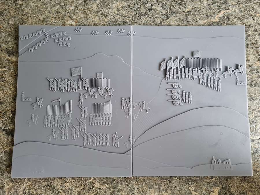
The 3D-printed tactile version of the illustration.
Image 3 of 4

A tactile version of the illustration next to the original document.
Image 4 of 4

A student using the tactile model.
The Carberry Hill files contain the full Carberry Hill print, as well as a slightly increased scale alternative that has been split into a left and right plate.
This document is a map showing an event that happened at St Peter’s Fields on the 16th of March 1819 in Manchester. At this time, only rich people could vote and machines had begun to take away jobs for people in the cotton industry, leading to unemployment and poverty.
This event came to be known as the Peterloo Massacre. A crowd of 60,000 men, women and children had gathered to protest about political reform (change) and rights for poor people. Local magistrates (people who held positions of authority and helped keep order) thought that reformers would get violent. They said the meeting was illegal and warned people to stay away. Despite this, the meeting went ahead and started peacefully. However, when the main speaker Henry Hunt arrived, the Manchester Yeomanry (men who owned land and volunteered to keep the peace) were sent to arrest him. They slashed their way through the crowd, killing 11 people and resulting in 400 people being injured. After the event the government introduced new laws to prevent meetings about political change.
Image 1 of 2

‘A plan of St Peter’s Field with the Avenues leading thereto’, with a key that shows the location of the magistrates assembled, constables near the hustings, Manchester Cavalry, hustings, Quakers’ Meeting House and reformers surrounding the hustings. Catalogue reference: TS 11/1056
Image 2 of 2

The tactile version of the map.
The St Peters Field map files contains two versions of the map: one with Braille labelling and the other with raised letter labelling. For each version a Word Document Key has been provided which details all information.
Both versions of the map are presented in four pieces, A, B, C, and D, which align left to right.
This map shows London after the Great Fire of London in 1666. It was drawn by Wenceslaus Hollar. It reveals how much of the city was destroyed in the fire.
The fire began on early Sunday morning on 2 September. It started in Pudding Lane in the shop of the king’s baker, Thomas Farrinor. Soon London was filled with smoke. The sky was red with huge flames from the fire. By Monday, 300 houses had burned down. London Bridge and St Paul’s Cathedral were both burnt. On Tuesday, King Charles II ordered that houses and shops be pulled down to stop the fire from spreading. By Wednesday, they had the fire under control. But by then, 100,000 people were homeless.
Image 1 of 2

Map showing London after the fire, 1667. Catalogue reference: ZMAP 4/18.
Image 2 of 2

The tactile version of the Great Fire of London map.
The Great Fire of London file contains a single complete version of the map, including raised letter labelling and matching Braille labelling.