How to look for records of... Architectural drawings
How can I view the records covered in this guide?
How many are online?
- Some
1. Why use this guide?
Use this guide for an overview of The National Archives’ collection of architectural drawings and related records and for advice on how to find them among our vast holdings.
The guide does not cover building contracts, accounts or correspondence.
We do not hold any architectural models.
Copies of all of the architectural drawings illustrated in this guide are available to buy through our Image Library.
2. What kinds of architectural drawings do we hold?
The National Archives holds many thousands of architectural drawings and related records, covering a very wide range of buildings and other structures, most of which date from the 18th, 19th and 20th centuries. These include plans, elevations, sections, perspective drawings and various other depictions and details of architectural works, including some iconic British landmarks and major engineering projects. We also hold site plans, which range from elaborate depictions of houses and grounds to simple outline block plans.
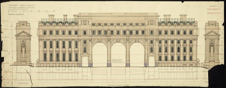
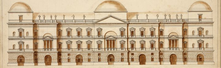
Elevation of Admiralty Arch in London, 1907 (catalogue reference WORK 30/3276). This drawing is held at The National Archives among the records of the Office of Works and its successors.
Before the 20th century the British government’s interest in architecture was largely confined to public and Crown buildings and schemes, and works by local authorities under various acts of Parliament. The records we hold very rarely represent the full range of drawings produced for any building project; we usually hold only a handful for a particular structure or scheme, although in a few cases a large number have survived (notably for the Houses of Parliament and the Royal Courts of Justice). Many older plans and drawings have not survived, and large numbers are held by other institutions (see section 7).
Because of the Crown’s landholdings, and litigation relating to privately-owned land, we hold some records of buildings and structures on landed estates; but except in the case of the Crown Estate we are seldom the best place to start a search for such material.
2.1 Crown Estate buildings
The majority of our architectural drawings relate to buildings which form part of the Crown Estate or have been the responsibility of the Office of Works and its successor departments and agencies. Among these are:
- royal palaces
- the Houses of Parliament
- government buildings
- buildings constructed for or used by the armed services
- ancient monuments
- works for ceremonial events such as coronations and state funerals
Many drawings are held among the records of the Crown Estate Commissioners, and the Office of Land Revenue Records and Enrolments and its predecessors and associated departments.
2.2 Municipal buildings and public works
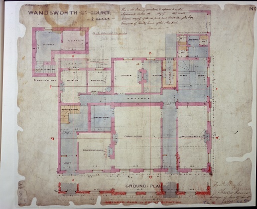
A ground floor plan of Wandsworth County Court in 1858, held among the records of the Office of Works and its successors (catalogue reference WORK 30/758).
We hold a range of drawings and plans relating to local municipal buildings, including schools, hospitals, poor law buildings, Metropolitan Police stations and other civic structures. The majority among the records of the Ministry of Housing and Local Government and successor and related bodies.
We also hold various plans relating to substantial complexes, such as housing estates, naval dockyards, or the Festival of Britain site, as well as a range of other sites and buildings.
2.3 Public transport constructions
Many plans and drawings of railway stations and hotels are among the records of pre-nationalisation railway, canal and related companies in the British Transport Historical Collection and those created or inherited by the British Transport Commission, British Railways Board and successors.
2.4 Buildings and constructions overseas
We also hold drawings of buildings and structures outside the British Isles, which were created or collected in the course of British government business abroad and in the work of the armed services, both in foreign countries and, during the years of the British Empire, colonies. Drawings of fortifications are particularly well-represented.
Plans and drawings from overseas are held among, though are not exclusive to, the records of the following departments:
- Colonial Office
- Dominions Office
- Foreign Office
- Foreign and Commonwealth Office
- Admiralty
- Air Ministry and related bodies
- War Office
3. How to search
The place to start a search is our online catalogue (see 3.1). However, many drawings are not listed in our catalogue, often because they belong to larger documents (‘parent’ files) whose catalogue descriptions are limited to broad details. Drawings are often filed or bound up with correspondence and other records generated in the course of the government business of which they formed a part. Some government departments created discrete series of maps and plans but even with these departments there are likely to be at least as many drawings among their respective text-based records.
The most detailed listings of drawings are those that appear in the published and unpublished catalogues, available in The National Archives library and reading rooms in Kew. If your online catalogue searches are unsuccessful you should turn to these paper catalogues (see 3.2 and 3.3), though you will need to visit us to do so.
As a last resort you can return to the online catalogue and try speculative searches of the records by searching for ‘parent’ files. For example, to find architectural drawings of a hospital you could try a search within Ministry of Health files for the area where the hospital is located, or for ‘hospital building programmes’ or any other description that may match your research topic.
3.1 Using our online catalogue
You can find some architectural drawings (usually described as ‘plans’) by using keywords to search for the short descriptions of them in our online catalogue. Some drawings and plans are individually described, others are only described as forming part of a file or a whole series in a wider description.
Start a search with the name of the building or structure; you can narrow searches by combining the name with terms such as:
- Plan/s
- Survey plans
- Diagram
- Drawings
- Cross-section
- Layout
- Elevation
- an architectural feature such as ‘foundations’, ‘towers’ and so on
Bear in mind that searching with ‘plan’ will find references to ‘plans’ and ‘planning’ which have nothing to do with architecture.
To target the records of a specific department, use the advanced search of our catalogue or the key series described in section 5 of this guide.
3.2. Using published catalogues available at our library and libraries elsewhere
Four volumes of Maps and Plans in the Public Record Office describe architectural plans and drawings, as well as maps, held at The National Archives (formerly the Public Record Office). Contents are arranged topographically under country names in use at the date of publication, and then chronologically within each region, country or place. They contain indexes of draughtsmen, surveyors, architects and cartographers, but not of subjects. The four volumes are:
- Part 1: British Isles c.1410-1860 (HMSO, 1967)
- Part 2: America and West Indies (HMSO, 1974)
- Part 3: Africa (HMSO, 1983)
- Part 4: Europe and Turkey (TSO, 1998)
3.3. Using unpublished catalogues available only at our building in Kew
The following resources, created by the Public Record Office, the forerunner of The National Archives, are held in the Map and Large Document Room at our building in Kew.
Searching by person: card catalogue
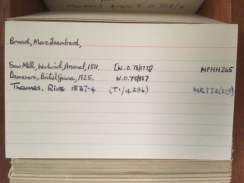
A card from the ‘Mapmakers’ card catalogue indicating the document references for architectural drawings by Marc Isambard Brunel, an engineer, father of Isambard Kingdom Brunel.
A set of drawers, labelled ‘Mapmakers’, contains a card catalogue of maps, plans and architectural drawings of various kinds. Indexed by the names of draughtsmen, surveyors, engineers, architects and cartographers, each entry provides very brief details of what is depicted in the document and the accompanying catalogue reference.
Searching by place: card catalogue
This card catalogue contains information about drawings that have come to light since the publication of the catalogues described in section 3.2 and includes places that they do not cover. It is arranged topographically, by names of countries as they were at the date of cataloguing.
Searching by place or subject: maps and plans summary catalogues
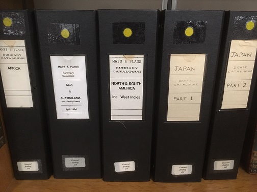
Part of the Summary Catalogue and the draft catalogue for maps and plans from Japan in our reading rooms at Kew.
For a few years in the late 1980s and early 1990s, maps, plans and drawings found with documents in series not consisting wholly of graphic material were recorded in a summary catalogue.
The catalogues are arranged topographically across a dozen or so files and there are three separate files providing subject indexes. The topographical and subject indexes both provide full document references.
Draft catalogue for maps and plans from Japan
A draft, manuscript catalogue of ‘Maps and plans’ for locations and constructions in Japan. It is arranged topographically.
4. How to search for the plans and drawings of specific architects
Not all the plans and drawings in our collection can be attributed to a specific architect but in some cases they are signed or otherwise identified as the work of a particular individual.
You can search by architects’ names in the following ways, though none of these methods offers a comprehensive search of the records:
- Search our catalogue using an architect’s name as your search term
- Consult the indexes of architects, draughtsmen and surveyors in the published and unpublished catalogues (see sections 3.2 and 3.3)
- Use the subject heading for architects and surveyors which forms part of the ‘Maps and plans summary catalogue’ (see section 3.3)
- Use the typescript index of signed drawings among the records of the Office of Works and successors (this index is not wholly reliable)
5. Key records series
The three tables in this section highlight those record series containing significant quantities of maps, plans and drawings relating to architecture and the built environment. These series were inherited from various government departments, notably the former Office of Works, which accumulated series of records consisting wholly or largely of plans and drawings of buildings, or maps illustrating aspects of the built environment, usually in relation to planning and development. Many architectural plans and drawings were filed in series which consisted principally of maps.
Click on the series references below to search within the respective series but keep in mind the following limitations:
- Catalogue descriptions seldom indicate the drawing material or medium.
- Catalogue descriptions seldom record the stage in the building project at which a particular drawing or set of drawings was produced (for example, presentation drawings, contract drawings, working drawings, record/as built drawings). In some cases, this can be determined from the drawings themselves, but it is not always easy to establish.
The tables overlap in places, and you can expect to find some types of drawings and plans in series appearing in more than one of these tables.
5.1. Drawings and plans of specific buildings, sites and schemes
A drawing from 1739 showing William Kent’s design for the Houses of Parliament (catalogue reference WORK 29/3358). The plan did not make it past the drawing board.
Copies of a card index created by the Office of Works contains information on the drawings in the various Office of Works series (department reference WORK) listed below, and is available in the Map and Large Document Reading Room at Kew. The card index provides a useful way to find records in the absence of detail in catalogue descriptions.
| Series | Description |
|---|---|
| AT 13 | Department of the Environment: Ancient Monuments Branch: Maps and Plans, 1971-1980 |
| BD 101 | Ministry of Public Buildings and Works and Welsh Office: Plans and Drawings relating to the Investiture of the Prince of Wales, 1969, 1968-1970 |
| HLG 5 | Local Government Board and successors: Housing and Town Planning Department and successors: Planning Schemes, Maps and Plans, 1905-1951 |
| HLG 6 | Ministry of Health and predecessors: Buildings and Works, Miscellaneous Maps and Plans, 1800-1919 |
| HLG 23 | Ministry of Health: Legal Branch: Sealed Plans, 1923-1937 |
| HLG 24 | Local Government Board and Ministry of Health: Legal Branch and predecessors: Rehousing Schemes of Statutory Undertakers, Sealed Plans and Schemes, 1890-1939 |
| HLG 111 | Ministry of Local Government and Planning and Ministry of Housing and Local Government: Legal and Parliamentary Branch: Miscellaneous Sealed Plans, 1951-1955 |
| LRRO 1 | Office of Land Revenue Records and Enrolments and predecessors: Associated Departments and successors: Maps and Plans, 1560-1981 |
| MEPO 9 | Metropolitan Police: Architectural Plans and Drawings, 1847-1965 |
| MH 14 | Poor Law Board and Local Government Board: Architect’s Department and Metropolitan Department: Poor Law Union Plans, 1861-1918 |
| PRO 50 | Public Record Office: Maps, Plans and Photographs of the Chancery Lane Building, 1896-1965 |
| PRO 55 | Public Record Office: Maps, Plans and Photographs of the Hayes Site, 1953-1973 |
| PRO 62 | Public Record Office: Maps, Plans and Photographs of the Kew Site, 1928-1978 |
| PRO 65 | Public Record Office: Former Repositories and Offices, Maps, Plans and Photographs, 1957-1977 |
| T 179 | Treasury: John F Kennedy Memorial Plan and Deed, 1964 |
| WO 385 | Board of Ordnance Office and successors: Royal Gunpowder Factory and successors, Waltham Abbey: Maps and Plans, 1783-1983 |
| WORK 29 | Office of Works and successors: Houses of Parliament: Plans and Drawings, 1698-1947 |
| WORK 30 | Office of Works and successors: Public Buildings in England: Plans and Drawings, 1656-1962 |
| WORK 31 | Office of Works and successors: Ancient Monuments and Historic Buildings: Plans and Drawings, 1666-1977 |
| WORK 32 | Office of Works and successors: Royal Parks and Pleasure Gardens: Plans and Drawings, 1653-1964 |
| WORK 33 | Office of Works and successors: Art and Science Buildings: Plans and Drawings, 1815-1952 |
| WORK 34 | Office of Works and successors: Royal Palaces: Plans and Drawings, 1662-1994 |
| WORK 35 | Office of Works and successors: Statues and Memorials: Plans and Drawings, 1821-1958 |
| WORK 36 | Office of Works and successors: Ceremonial: Plans and Drawings, 1685-1936 |
| WORK 37 | Office of Woods, Forests, Land Revenues, Works and Buildings and successors: Osborne House: Plans and Drawings, 1843-1952 |
| WORK 38 | Office of Works and successors: Miscellaneous Plans and Drawings, 1662-1951 |
| WORK 40 | Office of Works and successors: Public Buildings, Overseas: Plans and Drawings, 1852-1952 |
5.2. Drawings and plans of major civil engineering projects
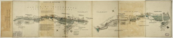
Manchester and Salford Exchange Stations layout plan from 1896, held among the records of the London and North Western Railway Company in series RAIL 410 (catalogue reference RAIL 410/796).
| Series | Description |
|---|---|
| AB 5 | Department of Scientific and Industrial Research and successor: Directorate of Tube Alloys and successor: Chalk River Project, Engineering Drawings, 1943-1976 |
| AN 23 | British Railway: Eastern Region: Signalling Plans and Track Diagrams, 1883-1968 |
| AN 31 | British Railways: London Midland Region: Station Plans and Drawings, 1948-1966 |
| AN 42 | British Railways: Southern Region: Signalling Plans and Track Diagrams, 1948-1962 |
| AN 48 | British Railways: Western Region: Station plans and Drawings, 1850-1960 |
| AN 93 | British Railways: London Midland Region: Signalling Plans and Track Diagrams, 1939-1979 |
| BK 7 | National Dock Labour Board: Premises Plans, 1949-1984 |
| BK 25 | National Dock Labour Board: Maps and Plans of Docks and Harbours, 1904-1983 |
| MT 8 | Railway Commissioners Returns and Plans of Iron Bridges, 1847 |
| MT 21 | Ramsgate Harbour: Deeds, Evidences and Plans, 1613-1939 |
| MT 54 | Light Railway Plans, 1896-1946 |
| MT 57 | Highways Maps and Plans, 1920-1964 |
| MT 91 | Board of Trade Railway Department: Drawings and Plans, 1840 – c1886 |
| RAIL 796 | Great Northern Railway Company: Working Plans and Sections, 1846-1914 |
| RAIL 1029 | British Transport Historical Records: Maps, Plans & Surveys of Canals and Inland Waterways, 1761-1974 |
| RAIL 1030 | British Transport Historical Records: Maps, Plans and Surveys of Individual Railway companies, 1824-1963 |
| RAIL 1031 | British Transport Historical Records: Maps, Plans and Surveys of British Railways, Canals and Inland Waterways, 1808-1964 |
| RAIL 1032 | Maps, Plans & Surveys: Railway Clearing House, 1870-1960 |
| RAIL 1033 | Maps, Plans & Surveys: Towns, Ports and Local Areas, 1834-1960 |
| RAIL 1034 | Maps, Plans & Surveys: London, & London Transport, 1870-1960 |
| RAIL 1035 | Maps, Plans & Surveys: General & Atlases, 1843-1961 |
| RAIL 1036 | Maps, Plans and Surveys: British Empire and Foreign, 1863-1956 |
| RAIL 1037 | Maps, Plans and Surveys: York Collection 1737-1958 |
| RAIL 1071 | Parliamentary: Deposited Plans |
5.3. Drawings and plans of military establishments
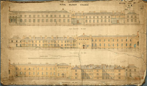
Elevations from 1880 of the front and back of Sandhurst Royal Military College (catalogue reference WORK 43/986).
| Series | Description |
|---|---|
| ADM 140 | Navy Board and Admiralty: Civil Engineer in Chief’s Department and predecessor: Maps and Plans, 1786-1956 |
| AVIA 62 | Air Ministry and successors: Estates Branch: Civil and Military Airfields: Maps, Plans and Papers, 1935-1968 |
| BD 54 | Welsh Office and predecessors: Plans of Airfields in Wales, 1937-1946 |
| WO 78 | War Office and predecessors: Maps and Plans, 1627-1953 |
| WORK 41 | Admiralty, Navy Works Department and predecessors: Naval Establishments: Plans and Drawings, c1760-1970 |
| WORK 43 | War Office, Directorate of Works and predecessors: Army Establishments: Plans and Drawings, 1713-1963 |
| WORK 44 | Air Ministry, Directorate of Works: Air Force Establishments: Plans and Drawings, 1914-1956 |
6. Architectural furnishings and fittings
Drawings of architectural details, fittings and furnishings may appear in many of the series listed in section 5, often relating to the contents of specific buildings. Other useful sources include:
- BT 183: Board of Trade: Utility Furniture Scheme: Files, 1943-1949, which contains large numbers of drawings
- WORK 25: Festival of Britain Office records, which includes many drawings relating to furnishings, fixtures and fittings in buildings on the Festival site
- DSIR 4: Department of Scientific and Industrial Research: Building Research Station: Correspondence and Papers
7. Architectural drawings held elsewhere
Numerous institutions around the world hold collections of architectural drawings and related records. This section details those with significant collections of material with a connection to our records in their history or content.
- Large numbers of plans and drawings created by local government and other bodies are held in local authority record offices. For their addresses and contact details, use the find an archive tool or consult British Archives: A Guide to Archive Resources in the UK by Janet Foster and Julia Sheppard (4th edition, Palgrave Macmillan, 2002).
- Historic England Archive – substantial collections of drawings created or collected by government departments are held by the Historic England Archive. Records shed light on the history of specific buildings built for or occupied by government departments, among other things.
- National Records of Scotland – holdings include government records relating to public works, and some records of former or present public utilities.
- National Library of Wales – holdings include government records relating to public works, and some records of former or present public utilities.
- Public Record Office of Northern Ireland – holds some records relating to British government in Ireland before 1922 as well as specifically Northern Irish records.
- The National Archives of Ireland – holds some records relating to British government in Ireland before 1922.
- National Monuments Record of Wales – this is the archive of the Royal Commission on the Ancient and Historic Monuments of Wales.
- Historic Environment Scotland – the archives include collections on ‘Scotland’s Urban Past’ and the work pf Sir Basil Spence, one of the most celebrated architects of post-war Britain.
- Research and Special Collections Available Locally – a hub for research resources relating to Ireland, including EHS: Built Heritage, which It aims to identify, record and protect the built, buried and underwater remains of human activity from prehistoric times to the present day.
- V&A + RIBA Architecture Partnership – a joint venture to bring together the drawings and archives of the Royal Institute of British Architects and the architectural drawings and photographs of the Victoria and Albert Museum. Material on buildings or architects, in the public or private sector, from the Renaissance to the present day.
- Royal Institute of British Architects – home to one of the largest and most diverse architectural collections in the world.
8. Further reading and resources
All of the publications listed here are available for consultation at The National Archives library in Kew.
The following two publications contain advice on records in our collection, with some information about plans and drawings:
Nick Barratt, Tracing the History of your House (2nd edition, 2006)
Cliff Edwards, Railway Records: A Guide to Sources (2001)
The following guides may help you with your keyword choices when searching our catalogue and more generally:
Robin Thornes and Vicki Porter, A Guide to the Description of Architectural Drawings (G K Hall & Co., 1994)
Toni Petersen and Patricia J Barnett, Guide to Indexing and Cataloguing with the Art & Architecture Thesaurus (Oxford University Press, 1994)
The following may also prove useful:
Angela Mace, The Royal Institute of British Architects: A Guide to its Archive and History (Mansell Publishing, 1986)
James Bettley and Richard Raper, Catalogue of the Drawings Collection of the Royal Institute of British Architects: A Cumulative Index (Gregg Publishing, 1989)
Eleonore Kissel and Erin Vigneau, Architectural Photo-reproductions: A Manual for Identification and Care (Oak Knoll Press, 2009)
A Guide to the Archival Care of Architectural Records, 19th-20th centuries (International Council on Archives, 2000)