How to look for records of... Public rights of way, roads and other highways
How can I view the records covered in this guide?
How many are online?
- Some
Contents
- 1. Why use this guide?
- 2. What are public rights of way and highways?
- 3. Rights of way on maps
- 4. Rights of way and highway legislation
- 5. Records of the removal of right of way status: extinguishments and stopping up orders
- 6. Notices of dedication and repair liability 1835-1959
- 7. Records of rights of way and highways on land owned by the Crown
- 8. Roads and rights of way on enclosure documents
- 9. Roads and rights of way in 19th century tithe documents
- 10. Rights of way in Valuation Office Field Books 1910
- 11. Turnpike and toll roads
- 12. Long distance walking routes
- 13. Further reading
1. Why use this guide?
This guide provides advice on where to look for records of public rights of way, roads and other highways in England and Wales. The National Archives is not the best place to start looking for these kinds of records and much of the advice in this guide directs you elsewhere.
Each local highway authority (county council or unitary authority) will have records of public rights of way in its area and local archives are therefore the best place to start a search.
The information in this guide is not a statement of law and we cannot provide legal advice of any kind. For advice on property boundary disputes you should consult the Land Registry pages on GOV.UK or contact a legal adviser.
You can find further advice on records of rights of way, highways and related subjects at the following websites and institutions:
- GOV.UK
- IPROW (Institute of Public Rights of Way and Access Management)
- Open Spaces Society
- Byways and Bridleways Trust
- The Parliamentary Archives
- British Horse Society
- Ramblers
2. What are public rights of way and highways?
Public rights of way allow the public to walk, or sometimes ride, cycle or drive, along specific routes over land which may belong to someone else – the land itself is often privately owned.
Though the term highway is popularly used to refer to roads, its legal definition covers any public road, track or path. Historically, a highway, which was also referred to as ‘the King’s highway’, was defined as a public passage for the use of the sovereign and all his or her subjects. The Highway Act 1835 defines highways as ‘all Roads, Bridges (not being County Bridges), Carriageways, Cartways, Horseways, Bridleways, Footways, Causeways, Churchways and Pavements’.
There are further, more detailed and contemporary definitions at Land Registry Title Deeds Online and the IPROW website.
3. Rights of way on maps
In this section you will find advice on the most significant kinds of maps that show rights of way, where they are held, whether at The National Archives or elsewhere, and some advice on how to find them. In section 8 and section 9 of this guide there is advice on some of the other kinds of records that contain maps showing rights of way and highways.
3.1 Definitive maps and statements 1949 to present
A number of public acts since the National Parks and Access to the Countryside Act 1949 (principally The Countryside Act 1968 and the Wildlife and Countryside Act 1981) have required that local authorities produce and, subsequently, review maps and statements showing and defining public rights of way in their area – these are known as definitive maps and statements. Footpaths, bridleways, byways open to all traffic and restricted byways are distinguished on the maps. Formerly, roads used as public paths were shown too.
Local authorities are required to make these resources available for public inspection. Some local archives may also hold old, as well as current, definitive maps and statements.
Contact the local authority directly or search for ‘definitive maps’ in our catalogue, using the filters on the left-hand side of the results page to restrict your search results to ‘Other archives’, as shown:
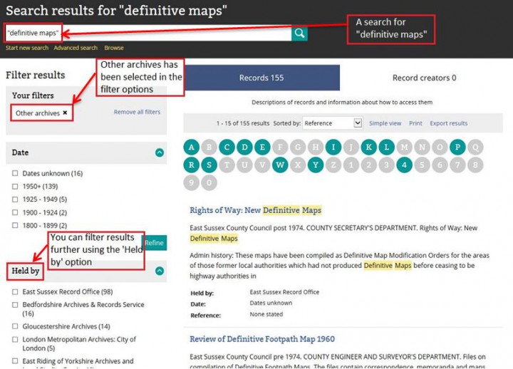
Filtering results after a search for “definitive maps” in The National Archives catalogue.
See the very useful guide to definitive maps (PDF) published by GOV.UK for an in-depth explanation of the maps themselves, rights of way in general and the legal framework that underpins it all.
3.2 Ordnance Survey maps 1951-2009
Until the 1960s, Ordnance Survey maps bore a disclaimer stating that the depiction of any road, track or path does not constitute evidence of the existence of a public right of way.
With the public availability of definitive maps, Ordnance Survey maps at 1:50,000 and 1:25,000 scales, from 1960 onwards, do indicate rights of way including footpaths, bridleways, restricted byways and byways open to all traffic, based on the definitive maps.
Although published Ordnance Survey maps are not sent to The National Archives as a matter of policy, there are some maps among the Ordnance Survey records held here. Those most relevant to rights of way are:
- OS 75 (1951-2009) – definitive maps sent by local authorities to Ordnance Survey for use in preparing published maps – click on the reference and search by county, borough or local authority district
- OS 78 (1959-2007) – public path orders (including definitive map modification orders) sent by local authorities to Ordnance Survey for use in preparing published maps (each of these usually include a map) – click on the reference and search by county
Papers about Ordnance Survey policy regarding the depiction of rights of way are in OS 1 and OS 11.
See section 8 of our Ordnance Survey guide for more information on where to find Ordnance Survey maps.
4. Rights of way and highway legislation
There have been numerous Highways Acts in the UK dating back to the 16th century, most of which contained sections on rights of way. See legislation.gov.uk for Highways Acts since 1835.
Other significant public acts affecting rights of way and highways, all available on legislation.gov.uk, include:
- Countryside and Rights of Way Act 2000
- Wildlife and Countryside Act 1981 (amended and largely repealed the 1949 and 1968 Acts below)
- Highways Act 1980
- Countryside Act 1968
- National Parks and Access to the Countryside Act 1949
5. Records of the removal of right of way status: extinguishments and stopping up orders
When the legal obligation to provide public access along a path, track, road or any other route ceases, the right of way, in legal language, is said to be ‘extinguished’ or ‘stopped up’.
5.1 Records of extinguishments – general
Notices about proposals to stop up or divert public rights of way and highways were, and to a lesser extent still are, usually published in the local press and in the London Gazette. Subsequently a legal order authorising the change is made. These extinguishment or stopping up orders are held in a variety of places.
MT 78 contains a large number of stopping up orders made between 1941 and 1974. Use the MT 78 series search to search this series by:
- name of parish
- name of town
- name of village
- name of Rural District Council
- name of Urban District Council
- for larger towns and cities, name of road or street
Look for stopping up orders in the following series by clicking on the references below and searching with the terms “extinguishment”, “stop up” or “stopping up”:
- Some orders are among the Housing Instruments and Consents in HLG 13; related registered files are in HLG 47.
- Orders made under the Town and Country Planning Acts 1944 and 1947 are in HLG 26 (registers in HLG 66).
- Orders made concerning the creation, stopping up and diversion of footpaths in Welsh counties and county boroughs are in BD 20.
- Orders made after 1956 by Liverpool Crown Court under the Liverpool Highway Act 1835 are in J 108 (earlier orders are in quarter sessions records held locally).
- Orders made by Manchester Crown Court under the Manchester General Improvement Act 1851 are in J 109 (earlier orders are in quarter sessions records held locally).
- licences to stop up footpaths 1852-1876 are in HO 141.
Copies of orders made under the Highways Act 1959 are likely to be held in local archives.
5.2 Records of extinguishments as a result of land requisitioned for war
The exercise of emergency powers to requisition land during the Second World War often affected rights of way over such land. Orders to stop up or divert highways under the Defence (General) Regulations 1939 and other relevant legislation are among the records in MT 78.
Use the MT 78 series search to search this series by:
- name of parish
- name of town
- name of village
- name of Rural District Council
- name of Urban District Council
- for larger towns and cities, name of road or street
Other relevant record series, which you can search by clicking on the references below and searching with the words “extinguishment”, “stopping up”, “rights of way” or “right of way”, include:
- MT 105 – includes a number of files about the closure of rights of way by the War Office under the Requisitioned Land and War Works Acts 1945-1948, including material about the continuing closure of ways across the East Lulworth Ranges in Dorset after the end of the Second World War.
- T 180 – records of the War Works Commission, set up in 1945 to deal with problems arising from the emergency use of private land. Includes a number of files about the closure of highways and footpaths at airfields, ordnance factories and other strategic sites.
- AIR 2 contains a number of applications to the Railway and Canal Commission for authorisation to close rights of way.
5.3 Records of extinguishments and stopping up orders pre-19th century
Click on the references below to search the respective series for pre-19th century stopping up orders (suggested search terms are provided in brackets):
- papers of the Treasury Solicitor from the early 16th century in TS 18 and TS 28 (search with “stopping up”, “rights of way” or “right of way”)
- records of both the proposed closure of old highways and footpaths consequent on enclosure of lands, and also the provision of alternative ways to replace the old roads and paths are in inquisitions ad quod damnum from at least the early 17th century until the 19th century, in C 202 – information can include the dimensions of ways and local field names over which the routes were to pass (there is an index in the printed version of this series, available only at our building in Kew)
There are also some stopping up orders from the late 17th century onwards in KB 16, some with maps and considerable background detail. These records, however, are hard to find as the series has not been described in any detail in our catalogue.
6. Notices of dedication and repair liability 1835-1959
Before 1835 a landowner could declare or, in the conventional legal language, could ‘dedicate’ a road as a public right of way and it automatically became the liability of the public to repair it – whether it was of any great utility or not. This changed with the 1835 Highways Act, Section 23 of which established that if a landowner proposed to dedicate a road or bridleway as a public highway and intended that it would be repaired by the public, notice had to be given in writing to the surveyor of the parish.
Some of these notices survive in local archives but there are none in The National Archives. This element of the law was repealed by the Highways Act 1959.
7. Records of rights of way and highways on land owned by the Crown
The records of the Crown Estate are held at The National Archives under the CRES department code. Some of these records contain information on rights of ways, roads and other highways, particularly when there were alterations to the land that affected rights of way, such as the building of new highways and turnpike roads.
Search for CRES records in our catalogue, particularly in the series listed below. Click on the series codes below to search within that series using the search terms suggested:
- CRES 2 (1513-1913) – by county or place name or the word “roads” or the phrases “right of way” and “rights of way”
- CRES 6 (1660-1918) – by year only
- CRES 35 (1706-1991) – by county or the name of a Crown estate e.g. Windsor or the word “roads” or the phrases “right of way” and “rights of way”
Records include agreements, surveys, correspondence and maps.
8. Roads and rights of way on enclosure documents
Many enclosure awards (legal documents recording the ownership and distribution of ‘enclosed’ land) contain information about the status of roads and other ways, including public paths and occupation roads. They may state who was responsible for their maintenance and for the maintenance of hedges and fences along the boundaries of fields. Some enclosure maps distinguish between major and minor roads but no inferences should be drawn from the absence of such information.
For more information about using these records, see our guide to Enclosure awards.
9. Roads and rights of way in 19th century tithe documents
For an understanding of tithe records and why they were created see our Tithes guide.
Although tithe maps may show rights of way and can provide all kinds of information about roads, footpaths, bridleways and other tracks, they were not compiled with any intention to demonstrate rights of way. Tithe maps and the records of apportionments that go with them should, therefore, be treated with caution when used to try to establish rights of way or public highways. The inferences that can be drawn from the depiction or non-depiction of a route will vary considerably from map to map.
Tithe maps and apportionments can, nevertheless, be rich in detail and some, as well as showing rights of way, can include information about:
- the condition of local roads
- the existence of turnpikes
- recent improvements to roads
- the names of owners of private ways
- whether roads are major or minor
Search for:
- Individual tithe files by parish and county in IR 18 (1836-c.1936)
- Tithe maps by parish and county in IR 30. Most maps in this series were drawn between 1837 and 1845
- Tithe apportionments by parish and county in IR 29. Most records in this series date from between 1837 and 1845
10. Rights of way in Valuation Office Field Books 1910
For an understanding of the Valuation Office survey carried out between 1910 and 1915 and more detailed advice on the records that were created as a result of it, see our Valuation Office survey guide.
The existence of a public right of way could be claimed as part of the initial valuation of the land that took place under the terms of the Finance (1909-10) Act 1910, and many ways are thus recorded in the Valuation Office Field Books. However, it should be noted that it is the mere fact of the existence of a way and not normally its precise location or course which is recorded.
For advice on searching for Valuation Office Field Books see section 4 of the Valuation Office survey guide.
11. Turnpike and toll roads
Turnpike roads were roads whose maintenance was funded by tolls levied on passengers. A turnpike was a gate across a road, usually a minor road or byway, opened to allow those who had paid the toll to pass. Many turnpikes were authorised by local Act of Parliament, and administered by turnpike trusts. From 1814 there was a requirement to deposit plans of turnpike roads with local authorities, most of which, if they survive, are in the Parliamentary Archives.
Turnpikes were managed by turnpike trusts which were set up under individual Acts of Parliament. The last Turnpike Act was passed in 1836. Maintenance responsibility was transferred in the latter part of the 19th century from turnpike trusts to highway boards.
There are large numbers of records relating to turnpikes in local archives and a significant number at The National Archives too. Search our catalogue with the following words and combinations for a variety of related records:
- turnpike
- “road tolls”
- “toll roads”
- roads AND tolls
12. Long distance walking routes
The responsibility for submitting proposals for long distance routes along public rights of way and for making arrangements with local authorities for the establishment of routes lay with the National Parks Commission.
Records of the National Parks Commission and the Countryside Commission are held at The National Archives under the department reference COU.
Search in the following series, in particular, for records related to long distance walking routes:
- HLG 92 (1941-1973)
- COU 1 (1949-1992)
- COU 2 (1950-1968) contains, among other records, minutes of the Long Distance Routes Committee, 1954-1966
13. Further reading
John Riddall and John Trevelyan, Rights Of Way: A Guide to Law and Practice, 4th edition (Henley-on-Thames and London, 2007). This and previous editions are often called the ‘Blue Book’.
Sarah Bucks and Phil Wadey, Rights of Way: Restoring the Record (Ilminster, 2012)