How to look for records of... Overseas maps and plans
How can I view the records covered in this guide?
How many are online?
- None
Contents
- 1. Why use this guide?
- 2. What we do and don't hold
- 3. How to search for and see our maps and plans
- 4. Major collections covering multiple territories
- 5. Australia, New Zealand, Canada, South Africa and other Dominions Office territories
- 6. India, Pakistan and Burma (Myanmar)
- 7. Other notable collections
- 8. Further reading
1. Why use this guide?
This guide will help you to locate historical maps, held at The National Archives, of towns, cities, regions and countries around the world. There is also some advice on how to find old plans of buildings, fortifications, harbours, and countless other installations, many in English and British colonies but others elsewhere around the globe.
For advice on finding maps and other documents specific to borders, boundaries and boundary commissions, see our guide to records of international boundaries.
For guidance on finding maps and charts of international and British waters produced by the Admiralty Hydrographic Department, see our guide to sea charts.
High resolution copies of the maps and plans pictured in this guide are available to purchase, along with many hundreds of others, through our Image Library.
2. What we do and don’t hold
We hold maps and plans generated or collected by the various departments of state responsible for the foreign relations of England, Wales and the United Kingdom since the 16th century. These include:
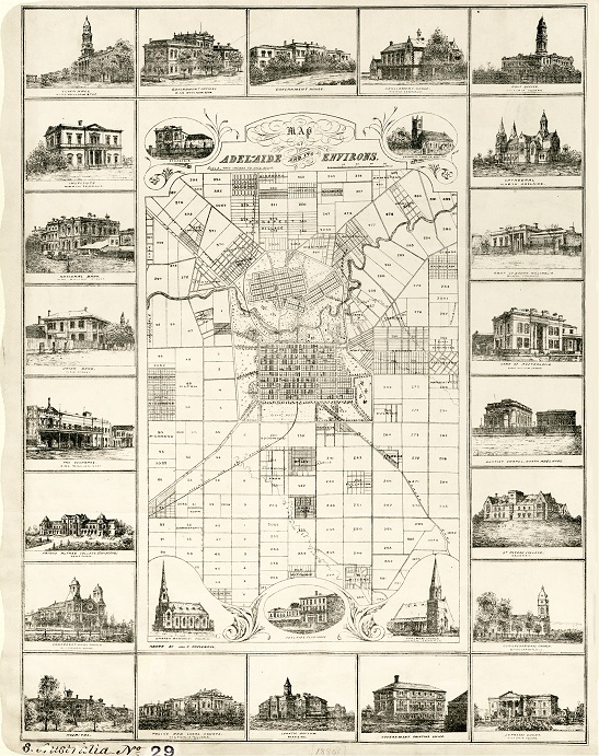
A Colonial Office map from 1880 of Adelaide and its environs, in South Australia (catalogue reference CO 700/SOUTHAUSTRALIA29)
- The State Paper Office (the offices of the Secretaries of State up to 1782)
- The Foreign Office (created in 1782)
- The Colonial Office (created in 1854)
- The Dominions Office (created in 1925)
- The Commonwealth Relations Office (succeeded the Dominions Office in 1947)
- The Foreign and Commonwealth Office (created in 1968)
Though maps were usually placed in the custody of departmental libraries, no section, division or unit within the departments listed above was created solely for the care of maps and they were acquired on something of an ad hoc basis.
Many maps were gathered by diplomats when abroad or by colonial governors and civil servants. Often they accompanied reports and despatches. A number were commissioned or purchased from map sellers in the United Kingdom, sometimes to assist comprehension of diplomatic and territorial relations abroad.
We don’t hold the records of the India Office and Burma Office – these are at the British Library. Many of the maps collected by the Foreign Office after 1940 have been transferred to the Royal Geographical Society.
3. How to search for and see our maps and plans
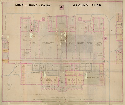
A ground plan of the Hong Kong Mint from 1864 (catalogue reference MR 1/895/2-3). This comes from a Colonial Office collection.
Very few maps and plans held here are available to view online and in most cases you will need to visit us or order copies to see them. First, however, you will need to find them among the tens of millions of records held at The National Archives. You can do this by:
3.1 Using our online catalogue
There are short descriptions of many maps and plans in our online catalogue. You can search for these using keywords and dates. Each description is accompanied by a document reference and details of how you can view the map or plan.
To narrow your search, use the advanced search and target records from specific government departments and from a specific year or range of years. To target a specific department you will need to enter the appropriate department reference in the reference fields. For example:
- For maps primarily before 1782 try targeting your search to the State Paper Office using SP as your department reference
- For maps primarily from 1782 to 1968 of territory outside of the British Empire try targeting your search to the Foreign Office using FO as your department reference
- For maps of British colonies try targeting your search to the Colonial Office using CO as your department reference
Alternatively, try a broad search first and narrow your search results following the search by using the filter options.
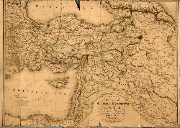
A map of the ‘Ottoman Dominions in Asia’ from 1828 (catalogue reference FO 925/2841). This map is from FO 925, one of the major collections of overseas maps held at The National Archives (see section 4).
Some maps and plans are held within larger files or volumes whose catalogue descriptions contain no mention of them. To find these you will need to visit us to search speculatively among records relating to a specific subject, country or territory. For example, given that treaties between nations can relate to territory, the correspondence and papers relating to treaties sometimes include maps used for illustrative purposes. Searching the catalogue with the name of a country or territory and the word ‘treaty’ could, therefore, lead to documents which contain maps.
3.2 Using printed map catalogues and indexes
There are several published catalogues of maps held at The National Archives. Each catalogue is arranged by region and country and contains lists of maps accompanied by short descriptions and catalogue references. All of these catalogues are available in The National Archives Library.
- P A Penfold, ed, Maps and Plans in the Public Record Office, Part 2: America and West Indies (London, 1974)
- P A Penfold, ed, Maps and Plans in the Public Record Office, Part 3: Africa (London 1982)
- Geraldine Beech, ed, Maps and Plans in the Public Record Office, Part 4: Europe and Turkey (London 1998)
In addition, there is a card index to the ‘Supplementary Map Catalogue’ in the reading rooms at The National Archives. It comprises catalogue references for maps and plans held outside of the major collections covered in section 4. It is arranged alphabetically by country, continent and map maker.
4. Major collections covering multiple territories
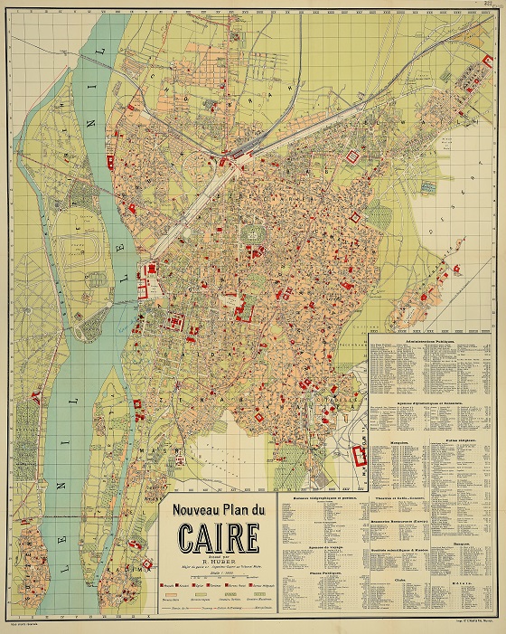
A city plan of Cairo from 1914 (catalogue reference MFQ 1/1379/59). This is a Foreign Office map, extracted from series FO 371 to be stored in series MFQ 1.
The vast quantity of maps held at The National Archives, numbering over a million, is scattered throughout the collection and is not restricted to the government departments listed in section 2. However, there have been some attempts, both by those government departments and by The National Archives itself, to gather together maps by theme, or sometimes format, and create coherent map series and departments.
The Public Record Office, the predecessor of The National Archives, created several dozen record departments during the 20th century in which were accumulated maps, plans and drawings extracted from the records of other departments following their transfer to the archives. This was done primarily as a preservation measure, usually for maps, plans and diagrams which exceeded the size of the document of which they formed a part. In the table below, they are the series whose references begin with an ‘M’.
| Collection | Series dates | Series reference | Search advice |
|---|---|---|---|
| Foreign Office library maps and plans
One of the largest collections of maps for the 18th and 19th centuries |
1700-1944 | FO 925 | Click on the series reference and search by place. |
| State Paper Office domestic and foreign maps
Maps of countries in Europe, the Americas, Asia and Africa and a few naval charts, town plans and atlases |
c1590-c1888 | SP 112 | Click on the series reference and search by place or browse by reference for a better sense of the regions described (the first 65 pieces have been transferred to other series so browse from piece 66). |
| Colonial Office maps and plans Series I | 1595-1927 | CO 700 | Click on the series reference and search by place, or browse by reference for a better sense of the regions described, including some descriptions in other languages, such as ‘Atlas des Colonies Francaises’ and ‘Deeutscher Kolonial-Atlas’. |
| Colonial Office maps and plans Series II | 1779-1947 | CO 1047 | Click on the series reference and search by name of colony, continent or by region (regions include Aden and Arabia; East Africa; South Africa; West Africa and Western Europe). |
| Colonial Office maps and plans post-1940 collection
As well as material from the Colonial Office, includes maps and plans collected by the Foreign Office, the Dominions Office, the Commonwealth Relations Office, the Commonwealth Office and the Foreign and Commonwealth Office |
1897-1984 but predominantly post-1940 | CO 1054 | Click on the series reference and search by name of country, continent or region (regions include Middle East; Indian Sub-Continent, Pacific, Central America and West Indies). There are maps of a number of Asian, African, South American and European countries and not just British colonies or ex-colonies. |
| Maps, charts, plans, and a small number of architectural and technical drawings collected together from various Foreign Office records | c1800-1966 but predominantly 19th century;
1798-1940 |
MPK 1; | Click on the series references and search for catalogue descriptions which include not just the name of the place depicted on the map but details of the original document from which the map was extracted. For example, the ‘Map of the Hedjas and the route of the [Egyptian] Army to Assir’ listed for MPK 1/36 includes the detail ‘enclosure to Col Campbell’s despatch of 8 November 1836’. You can also browse either series: browse MPK 1; browse MPKK 1. |
| Maps and plans collected together from various Colonial Office records | 1612-1949 | MPG 1 | Click on the series references and search for catalogue descriptions which include not just the name of the place depicted on the map but details of the original document from which the map was extracted. You can also browse either series: browse MPG 1; browse MPGG 1. |
| Maps, plans, topographical views, architectural and technical drawings from dozens of government departments including Foreign Office, Colonial Office and Dominions Office | 1500s-1966;
1565-1962 but predominantly post-1800 |
MR 1 | Click on the series references and search for catalogue descriptions by the name of the place depicted on the map. You can also browse either series: browse MR 1; browse MFQ 1. There is nothing from overseas before 1600. |
| Maps, plans, architectural and technical drawings from government departments including Foreign Office and Colonial Office | 1587-1966
1770-1954 |
MF 1 | Click on the series references and search for catalogue descriptions by the name of the place depicted on the map. You can also browse either series: browse MF 1; browse MRQ 1. There is nothing from outside of Britain and Ireland before 1775. |
| Maps, plans, architectural and technical drawings from government departments including Dominions Office and State Paper Office | c1509-1960
c1679-1952 |
MPI 1 | Click on the series references and search for catalogue descriptions by the name of the place depicted on the map. You can also browse either series: browse MPI 1; browse MPII 1. |
5. Australia, New Zealand, Canada, South Africa and other Dominions Office territories
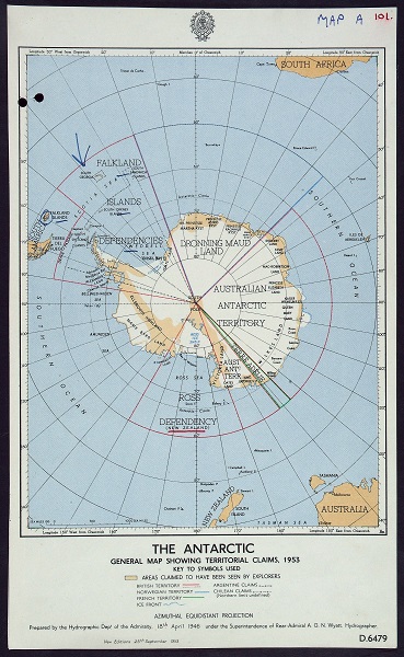
A Dominions Office map showing territorial claims on the Antarctic in 1953 (catalogue reference DO 35/6984).
In 1925 the Dominions Office was established to administer the semi-autonomous territories of the Commonwealth as well as a number of anomalous territories. This included:
- Australia
- New Zealand
- Canada
- South Africa
- Southern Rhodesia
- the Irish Free State
For a more detailed breakdown of the territories see the administrative background of the Dominions Office.
Before 1925 and since 1907, administration of the dominions had been undertaken by the Dominions Division of the Colonial Office.
There are many record series containing maps and plans from the Dominions Office and its predecessors but the following three hold significant quantities:
| Collection | Series dates | Series reference | Search advice |
|---|---|---|---|
| General correspondence of both the Dominions Office and Commonwealth Relations Office | 1915-1971 | DO 35 | Click on the series reference and search by name of country, continent or region and the word ‘map’. |
| Documents relating to treaties and agreements with various Commonwealth countries | 1856-1965 | DO 118 | Only some of the documents in this series contain maps but whether a map is included with a file is not always noted in the catalogue. Searching is therefore largely speculative and inclusion of the word ‘map’ in your search does not provide definitive results. Click on the series reference and search by name of country, continent or region – it will only be once the file is in front of you that you will know whether or not it contains maps. |
| Correspondence of the High Commissioners of southern African states | 1843-1965 | DO 119 | Only some of the documents in this series contain maps but whether a map is included with a file is not always noted in the catalogue. Searching is therefore largely speculative and inclusion of the word ‘map’ in your search does not provide definitive results. Click on the series reference and search by name of country, continent or region – it will only be once the file is in front of you that you will know whether or not it contains maps. |
6. India, Pakistan and Burma (Myanmar)
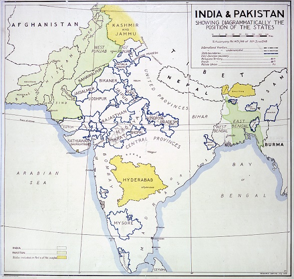
A 1948 map of India and Pakistan used by the Foreign Office (catalogue reference MFQ 1/1145). As is the case with large numbers of our maps, this map has been extracted from a Foreign Office series (in this case, FO 371) to be held with other maps and plans stored together.
The India Office was established in 1858. Before then British administration in India had been undertaken by the East India Company and the Commissioners for the Affairs of India. Records, including maps, of the India Office and the East India Company are held at the British Library (though at The National Archives there are a few maps used by the India Office which were inherited by successor departments in CO 1047 and CO 1054).
In 1937 responsibility for Burma passed to the Burma Office. Maps and other records of the Burma Office are also held within the India Office collection at the British Library. Burma did not join the Commonwealth when it attained independence in 1948 and responsibility for relations with Burma consequently passed to the Foreign Office.
Responsibility for relations with India and Pakistan passed to the Commonwealth Relations Office on their independence in 1947. The new department was formed that year by the merger of the Dominions Office and the India Office.
For maps of post-independence India, Pakistan and Burma use the advanced search in our catalogue to search by year or range of years and target your search to the following department references:
- FO, FCO and MFQ for Burma
- DO, FO, FCO and MFQ for India and Pakistan
7. Other notable collections
7.1 Post-First World War maps
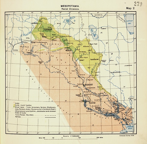
A map employed at the Paris Peace Conference in 1919, showing the ‘racial divisions’ in Mesopotamia (catalogue reference FO 608/96).
Search in FO 373 and FO 608 for maps produced during the Peace Conference following the First World War.
7.2 Plans of 16th-century towns and harbours
SP 46 contains a small collection, numbering ten or fewer, of maps and plans of the time of Elizabeth I. They are mostly plans of towns and harbours.
7.3 Maps of 17th-century Europe and America
Maps and plans collected by Sir Joseph Williamson, Keeper of the State Papers from 1661 to 1702, including maps of America and Europe and plans of forts, are in SP 9.
8. Further reading
The following books are available in The National Archives’ Library at Kew. They may also be available to buy from The National Archives’ shop.
Mandy Banton, Administering the Empire, 1801-1968: A Guide to the Records of the Colonial Office in The National Archives of the UK (Institute of Historical Research and The National Archives, 2008) – this title is also available from our shop
Michael Roper, The Records of the Foreign Office 1782-1968, Public Record Office Handbooks No.33 (Public Record Office 2002)