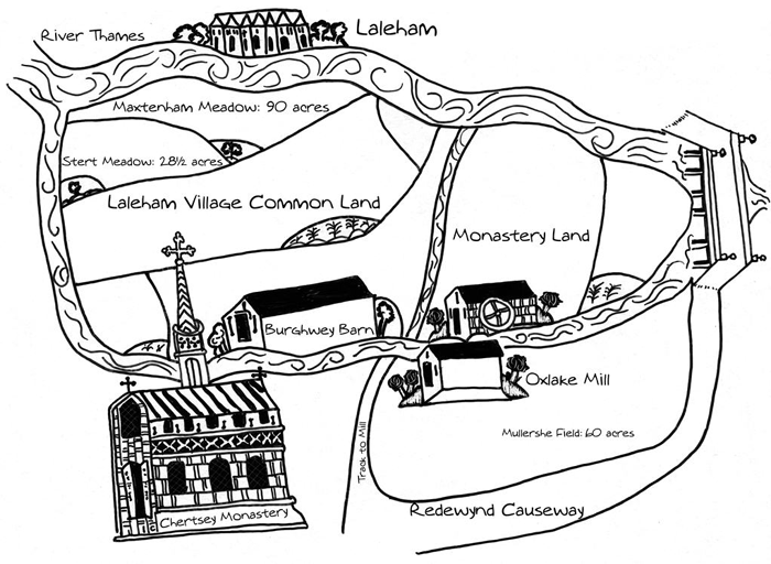
Map description
Map showing a river connected in a circle. It flows from the top left corner, labelled ‘River Thames’, splits in two, and then joins together and flows out again at the far right.
The right branch of the river that splits from the top left runs across the top of the map. It flows next to a group of houses labelled ‘Laleham’. Underneath, inside the circle formed by the river, are multiple fields. The top field is labelled ‘Maxtenham Meadow: 90 acres’. The field underneath is labelled ‘Stert Meadow: 28.5 acres.’ Underneath is an area labelled ‘Laleham Village Common Land’.
The river flows to a bridge on the far right of the map, where the two sides of the circle join and keep flowing underneath the bridge and off the map. Going clockwise to follow the branch of the river that runs at the bottom of the map, we see it flows next to a mill house labelled ‘Oxlake Mill’. The area above the mill, inside the river circle, is labelled ‘Monastery Land’. The area underneath the mill, outside of the river circle, is labelled ‘Mullershe Field: 60 acres’ and a road underneath it is labelled ‘Redewynd Causeway and ‘Track to Mill’.
The river keeps flowing next to a building labelled ‘Brughwey Barn’. Underneath this, just outside the river circle, is a large church labelled ‘Chertsey Monastery’.
The river then flows up to join with the initial junction.
1. This is a medieval map of Chertsey.
- Find the following buildings on the medieval map (use the transcript if you need to). Briefly say what activity took place there.
- Oxlake Mil
- Monastery of Chertsey
- bridge
- the village of Laleham
- Burghwey Barn
- Redewynd Causeway
- track leading to mill
- What is the largest building on the map?
- What does the size of the Abbey tell you about religion in the Middle Ages?
- How accurate do you think this map is?